ALIEN INVASION: COMING TO A BAY NEAR YOU

No, it’s not the latest summer blockbuster. The sacred haunts of the kayaker are being invaded. This is not the familiar invasion of fellow paddlers (a mixed blessing), but a new and more insidious invasion by other species altogether.
Cruise along the northern Mediterranean coast, and you will find that the shallow sea-grass beds that once teemed with life are now a desert of “killer” green algae, devoid of fish and invertebrates. From British Columbia to California, tranquil estuaries that echoed with flocks of migrating birds are now overgrown with acres of new salt marsh, obscuring the shoreline from birds and boaters alike. Along the volcanic rocky shores of Hawai’i, a new barnacle has taken up residence; the coast of South Africa is being invaded by an aggressive intertidal mussel; New Zealand and Australia are unwilling hosts of new seaweeds. Almost everywhere we paddle, old species are being swapped for new.
But new is not necessarily better.
Aliens, exotics, introductions, invaders…they go by many names, but all of these species share the common trait that they are spreading to places they don’t belong. They not only affect kayakers, but snorkelers, scuba divers, fishers, clam diggers, and other boaters. They can carry parasites and diseases. (Some of them are parasites and diseases.) They can damage fisheries, tourism, boating, property values, and industry. They can damage native plants, birds, fish, and mammals and disrupt the very natural world we paddle out to enjoy. That’s the bad news. The good news is that kayakers in particular can help marshal the defenses against them.

Anything can be an alien: seaweeds…
Do you dream, perhaps, of a Mediterranean vacation, floating silently over the teeming life of warm, shallow sea grass beds, trolling slowly for your dinner? When you go, you may catch more seaweed than fish on your line. Along the northern coast of this inland sea, the “killer” green alga called Caulerpa taxifolia is rapidly taking over. Divers first noticed Caulerpa in a small patch outside the Monaco aquarium in 1984. Recognized as a tropical species commonly used in aquaria, no one thought it would survive the cool water temperatures of winter. But this seaweed menace proved more robust than expected, and spread quickly along the coast into France and Spain, and as far east as Turkey.
Today, Caulerpa’s feathery green fronds and snaking root systems cover over 3,000 hectares (7,000 acres) of shallow seabed. And cover they do: rocks, sand, mud, seagrass beds; nothing is safe from its encroachment. Although Caulerpa is not toxic to humans, fish and sea urchins avoid it and seek more familiar ground-no easy task, when Caulerpa covers up to 100% of the ground, down to a depth of 35 m (114′). So much for catching dinner.

…plants…
Perhaps you are eschewing a sun-drenched holiday to explore the misty rainforest estuaries of the Pacific Northwest? Beware the invading smooth cordgrass, Spartina alterniflora. A beloved native of the east coast’s signature salt marshes, this grass is now a scourge of west-coast estuaries, where its characteristic circular patches expand across the tidal flat and displace native mud-dwellers.
Smooth cordgrass in the Pacific was first discovered in Willapa Bay, Washington, in the late 1800s. Its precise origin remains a mystery, but it was probably introduced accidentally, mixed in either with oyster shipments or with the rock and dirt ballast of wooden sailing ships. Spartina was later planted in other Northwest bays to control erosion and create duck (and duck-hunter) habitat.
Simply by growing along the water’s edge, smooth cordgrass drastically alters the shoreline. Its tall, stiff stems and long green leaves slow the flow of water, causing sediments to build up so high that the growing marsh is raised above the tideline. The semi-terrestrial meadow is no longer a suitable habitat for certain intertidal clams, for clam diggers (there goes dinner, again), or for the thousands of migratory and resident birds that depend on these estuaries for food. Boat access is affected too: with the ocean now farther away, you can no longer simply slide into your kayak from your backyard.
Invasive tendencies seem to run in the family: a second species of Atlantic cordgrass is also invading the Pacific, a South American cordgrass is invading North America, and worst of all, an English cordgrass planted widely in Europe, China, and Tasmania, is spreading rapidly around the world.

…animals…
Headed instead for the languid, coffee-colored waters of the Mississippi bayou? Keep your eyes open for nutria (Myocastor coypus), an overgrown swamp rat that may appear on the riverbank or even on a restaurant menu. These 20-pound nocturnal rodents were introduced from their native South America to the Gulf coast and southeastern states in the 1930s and ’40s for their fur, and at one time a breeding pair fetched up to $2,500 US.
Unfortunately, the demand for nutria fur can’t keep up with their vigorous population growth: a female typically matures at 5-8 months, producing litters of 4-6 young up to twice a year. Their predators-mostly alligators, but also turtles, gar, cottonmouth water moccasins, hawks, owls, and eagles-can’t keep up either. As a result, these hungry rodents, each armed with inch-long orange incisors, are excavating the coastal marshes and riverbanks of the Gulf States. A single animal can eat up to 25% of its body weight in plants per day. Not only does this activity destroy coastal vegetation, but it also reduces habitat available for native muskrat and waterfowl. Nutria also venture inland, devouring rice, sugar cane, soybean, alfalfa and corn crops and burrowing through protective levees.
In addition to their voracious appetites, nutria carry a parasitic roundworm, or nematode, whose larva can burrow into human skin, causing a severe “marsh itch” or “nutria itch” requiring medical attention.

…even microscopic diseases.
Some invaders are much smaller, but no less destructive. Beaches everywhere are increasingly closed to clam and mussel harvest, with posted signs warning of red tide, the blooms of toxic single-celled algae that cause paralytic shellfish poisoning. These outbreaks have recently been associated with the global transport of ballast water in commercial vessels. A ship that takes on water in a bloom area may carry the algae to a new port, initiating a new outbreak there. Indeed, the resting stages of toxic algae have repeatedly been collected from the sediments in ballast tanks of ships sailing into Australian waters.
Viruses and bacteria are carried too: over 90% of the ships entering Chesapeake Bay carry epidemic cholera in their ballast tanks, and in 1991 cholera was introduced to Mobile Bay, Alabama, in the ballast water of a ship sailing from South America.

Not just in the sea
Aliens are also invading lakes and rivers, forests and fields. Paddling in the North American Great Lakes, you will encounter infestations of the European zebra mussel fouling beaches, boat hulls, piers, and power plant water intakes. The native plankton-eating fish you see in the water below you are competing with a tiny, spiny European water flea for food. That appealing-looking beach may in fact stink with piles of rotting alewife, an introduced coastal fish that also competes with native chub and whitefish. Salmonids, introduced partly to control alewife, are in turn eaten by introduced lamprey. And the lamprey prey on other fish, including steelhead (introduced) and walleye, whitefish, and burbot (native).
Fish introductions are altering freshwater foodwebs around the world, and waterways everywhere are clogged by introduced aquatic plants like purple loosestrife, hydrilla, water-hyacinth and Eurasian milfoil.
You will encounter plant and animal invaders ashore, too. In California, you may clamber over South African ice plant to pitch your tent under an Australian eucalyptus tree. When you unroll your sleeping pad in Hawai’i, you keep a wary eye out for South American fire ants; in South America, for Africanized killer bees; in Africa, for the thorns of Australian acacia trees; in Australia, for the dung of European sheep. It seems that certain species, like certain familiar fast-food joints or soda brands, may soon spread to every place you travel.

An accelerating problem
As invaders accumulate, they stamp out the uniqueness of an ecological community, and convert it to an international hodge-podge of aggressive competitors and predators. Over 40 species of marine invaders are found in Chesapeake Bay, over 50 in Coos Bay, Oregon, over 90 in Port Philip Bay, Australia, and over 100 in the Great Lakes, San Francisco Bay, and the eastern Mediterranean. As a unit, they represent one of the greatest threats to endangered species in the U.S., second only to habitat loss, to which they also contribute. Their estimated costs in control and eradication run into the billions of dollars annually, in the U.S. alone. And the flood of new arrivals shows no signs of slowing. How do these species become such a problem?

Planes, trains and automobiles

By definition, an invasion doesn’t happen by itself. It needs help, and that help – be it intentional or not -usually comes from humans. Every species is native to some place in the world where it belongs. Any species that travels to another place, a place it could not walk, swim, hop, jump or fly to by itself, is labeled introduced. And these species travel the same way we and our stuff do: in airplanes, boats, cars, trucks, packages, and sometimes even our pockets.

Accidental tourists
Let’s start with boats. Commercial ships carry thousands of tons of ballast water, port water that is pumped through hull openings into tanks that keep the ship stable at sea. This ballast water typically teems with tiny larvae, the microscopic stages of sea life, that are readily sucked up into a ballasting ship, transported farther and faster than they would naturally drift in ocean currents, and then emptied out into a new port. Zebra mussels are perhaps the most famous ballast-water invader, arriving in North America from Europe in the mid2980s and costing an estimated $5 billion in control efforts over 10 years.
Traveling in the other direction, the North American comb jelly, Mnemiopsis leidyi, sailed to the Black Sea at around the same time. Swimming like a predatory vacuum cleaner, this jelly’s population soared as it swallowed up larval fish and the microscopic organisms the fish eat. In the wake of this double whammy, commercial fisheries around the Black Sea crashed precipitously.

Historically, ships carried not water but dry ballast, port-side rocks and dirt full of plants, seeds, and insects, that was dumped out at the next beach, often a continent away. And unlike modern steel hulls coated with anti-foulants, older ships had wooden hulls riddled with species of ship worm, sponge, seasquirt, and seaweed that are now found the world over.
As ships were developed to carry water, so water was rerouted to carry ships. From the mid2800s to the mid2900s, water bodies that had been isolated for millennia were suddenly connected by canals. In 1869, the Suez Canal joined the Red and Mediterranean Seas; in 1914, the Panama Canal linked the Atlantic and Pacific; through the 1950s, the St. Lawrence waterway pushed west from the Atlantic to Lake Superior. Over 25,000 kilometers (15,500 miles) of canals now link the river cities of western Europe, stretching as far inland as Georgia. And where ships could sail, so too could-and did-fish swim and larvae drift.
Recreational boats, including kayaks, typically don’t carry water ballast, but they can carry a host of organisms on their hulls and trailers. Zebra mussels, for example, can survive out of water for days and their spread through lakes of North America is closely tied to patterns of boater traffic.

nvited invaders
Species introduced in ballast water are inadvertent hitchhikers, but other invaders are introduced on purpose. Like agriculture on land, the industry of aquaculture ships marketable species worldwide. Thus, Japanese oysters have been grown in Europe, Canada, the U.S., China, Korea, New Zealand and Australia. Mediterranean mussels are grown in both the Atlantic and Pacific oceans. In the U.S., Atlantic lobsters were introduced to the Pacific coast and Pacific clams to the Atlantic.
For commercial and recreational fisheries, the story is similar. Atlantic shad were shipped to San Francisco in the 1870s and spread rapidly up the coast to British Columbia. Pacific salmon now thrive in the Great Lakes. Atlantic salmon, which failed to establish despite repeated introductions in the early 1900s, have now escaped from net pens and are reproducing in the rivers of Vancouver Island. In the late 1800s and early 1900s, European carp were shipped enthusiastically to ponds and streams across North America; today, brown trout and rainbow trout are still stocked in non-native locations.
Along with these intentionally introduced species have come a host of hitchhikers: for example, some fifteen species of clam, snail, and other invertebrates were inadvertently introduced to the Pacific Northwest with Atlantic and Japanese oyster shipments, including at least three oyster predators and parasites.
On land, invasion pathways are broadly similar: inadvertent introductions, intentional introductions, and their hitchhikers. Plants and insects travel in shipments of wood and produce, on car tires, in train cars. Ornamental plants are introduced, and soil nematodes come with them. Invaders sneak in as unseen pests in the fruit in our luggage, and are imported for biocontrol of agricultural pests, which are often invaders themselves as well.

Reducing the risk
Around the globe, humans are, inadvertently and intentionally, smearing the world’s species across their natural boundaries and homogenizing communities that were once distinct. In the process, we are generating a host of health and environmental risks. How can we slow this onslaught? First off, not all introduced species survive. Of those that do, not all spread vigorously or reach pest proportions, and many go unnoticed for decades.
The trouble is, the science of predicting which invasions will be successful is only just beginning. Once a species has arrived, controlling it is typically neither pretty or, often, effective. It may take years of physical work, chemical application, and sometimes even the introduction of other, non-native predator species.
Since we do not yet know reliably which invasions will be benign and which disastrous, and since control efforts are at best challenging and at worst cause even further problems, the best way to avoid harmful and expensive future problems is to prevent species from invading in the first place. Luckily, since humans are doing the introducing, humans can also stop it.

Don’t be a vector
On land, some of these precautions are already evident. When you return to the U.S. mainland from Hawai’i, your luggage is inspected for fruit pests that could damage mainland crops. When you fly into certain countries, your airplane may be sprayed with insecticides. During the current hoof-and-mouth epidemic, even Prince Charles had to wipe his feet upon arrival in the U.S. On a smaller scale, we can implement our own preventive standards for the places we explore.

The simplest guideline is this: Don’t be a vector. Invasive species get transmitted just like the flu does-by people. The same reason you stay home from work when you’re ill (or at least, that’s what you tell the boss as you pack up your dry bag) is the reason to leave other species at home when you travel. You are protecting the places you visit and the native species that live there. Both during and between trips, four simple tips can help reduce the risk of invasions.

On trips:
1. Report any unusual plants or animals in your local waters to your area fish and wildlife department, aquarium, or university. Study posters and other materials at marinas to recognize invaders in your area. By keeping an eye out for new arrivals, you can play an important role in invasion early warning.

2. Rinse off hulls and trailers at the take-out site to avoid moving pesky hitchhikers from one water body to the next (on any kind of boat).

3. Wash tents and other gear between trips to remove unwanted seeds and pollen grains. In the same way, rinse off your boots before exploring inland on your next trip. You can even wash off your car tires before visiting national parks and other protected areas.

4. Bring your unused bait home rather than dumping it: even if you can’t see them, live non-native species may be present on baitshop bait.

Between trips:

1. Don’t dump “live” trash. When you purchase shellfish from the store, throw the empty half-shells in the garbage, not onto the beach. Even if the shells look clean, they may be host to some non-native hitchhikers. Similarly, if you order live shellfish or other organisms for restaurants, classrooms, or anywhere else, throw the packing material in the garbage (even if it’s live plants or seaweed). Don’t risk starting an invasion.

2. Don’t release your pets into the wild: goldfish (or any other fish), birds, cats, dogs, and other animals can become feral, with devastating impacts on native species. In Hawai’i, for example, introduced avian malaria and feral cats are together driving native birds extinct. For the same reason, if you purchase lobster or any other live shellfish, but at the last minute can’t bring yourself to throw them in the pot, don’t release them at the shore-give them to a neighbor instead.

3. Seek out native trees, shrubs and flowers when you visit a garden nursery. Avoid planting exotics-they may use your yard as a launch site for a new invasion.

4. Get involved in local restoration projects to eradicate invaders and re-establish native species. Many local, regional and national parks will be delighted to have your help.

Whether we’re out on the water for an afternoon, a weekend, or a month, our motivation is the same: to see the land and seascape from a different perspective, to enjoy proximity to the natural world. But by doing so, we can inadvertently contribute to damaging this resource, our health, and our economy. Introduced species are an expensive and environmentally devastating challenge; kayakers are in a unique position to help reduce the risks.

Paddling at the Drop of a Hat Be ready for any paddling opportunity

Laurie’s voice leapt out of the telephone one Friday night. Hey, Mary! Bruce and I are going out tomorrow evening for a short overnight – want to join us? We’ll put in at Northfield at six, paddle up to the lean-to at Munn’s Ferry, and camp there, then paddle back on Sunday morning. We’ll be back at the cars before noon. We don’t have the whole weekend free for a trip, but we’re itching to get out on the water.
As she spoke, I did a quick mental review of my weekend schedule. No problem fitting in this short trip. I remembered that the morning forecast had been for a cool, cloudy weekend, but there were no big storms coming in. What about gear? It was March, the off-season in Massachusetts, and I hadn’t been out much over the winter, but all my gear was accessible and ready to go.

Sounds like a great idea, I said. What about food?
We’ll eat an early supper before we put in. Bruce is in charge of bacon and eggs for Sunday morning. Bring your favorite hot beverage, and some of those divine lemon ginger scones.

After the phone call, I walked over to my desk, pulled out my kayak gear list folder and flipped through it to the list for overnight trips. If it were the middle of summer, I would hardly need to look at it, but in March, the overnight list helped to jog my memory. In short order, I’d be fully prepared and equipped for a mini-vacation.

Sounds simple and delightful? It was, largely because of our ready-to-go attitudes, the nearby spots to overnight, and especially the systems we use for keeping our kayak gear organized. Often, one of the biggest barriers to getting out kayaking for most paddlers is scattered or unready gear. With some pre-planning, the right attitude and gear systems, you can easily get out on the water more often. Efficient gear systems can help you be ready to seize opportunities when they arise. You’ll also ensure that you won’t arrive at the launching site and realize your VHF radio batteries are on their last legs or that you forgot your flares.

Gear
A number of my paddling friends have told me they envy how often I go paddling. Having a flexible schedule helps, but a key component to how I get out on the water so frequently is my gear systems. For paddlers without efficient gear systems, packing for any trip is like packing for the first trip of the season: they are out of practice and their gear is buried under other stuff. I know many kayakers who would like to paddle more frequently, but they are put off by the time and hassle required to get all their gear ready to go. It is also not unusual for paddlers to rush through their preparation and head off on a trip without all the gear they need.

Keeping kayak gear handy is part of my daily routine in the six months of prime New England paddling season. To facilitate this routine, I have developed pre-trip, on-the-water, and post-trip systems.

Pre-trip
Develop a list of the gear you need for different trip lengths and seasons. (See list on following page for guidelines.) You should have all of the gear appropriate for the paddling you are doing, a place to store it between trips, and a system for maintaining and organizing it. For my almost-daily paddles in the summer, I use my car as a boathouse. Stuff packed in a car may be subject to high heat. I don’t store heat-sensitive items like my camera, radio, or drysuit in the car, but some of my more low-maintenance gear stays in my car all summer. I have a dry bag – my ‘day pack’- and a plastic bin that holds my PFD, pump, paddle float and paddling clothes and shoes. The plastic storage bin keeps the car dry when I dump in wet gear after an outing.

I keep my kayak locked on top of my car. I made a cover of sun-protective cloth to preserve the boat from harmful rays. I keep a gear checklist on my dashboard and double check it before I leave home to make sure I have everything. Every day in the summer, when I head out from the house to go to work or wherever, I sit in the car before driving off and I run down my list, reviewing what I need for the day.

Not everyone has a car they use for a boathouse. Most paddlers, however, can turn some part of their home into an efficient boathouse, by creating spaces to store and maintain their gear. Buy or build storage bins to hold equipment between trips, preferably near where you can hang wet gear to dry. If you use rechargeable batteries for your VHF radio or other electronics, it is handy to have an outlet nearby where you can plug in a charger.

Figure out which gear needs which type of storage area, especially in terms of temperature and dryness. Some equipment, especially dry suits and neoprene paddling clothing, should be rinsed and hung in a cool dry place rather than be packed away. Any dampness may lead to mildew. To transport equipment between your storage areas and your car or launching spot, develop a system such as using bags or portable bins. Such a routine will help you make sure you have everything, and will take less time than if you’re juggling lots of loose items.

On the water
Figure out standard places to stow gear on or in your boat, including how many and what size dry bags or other gear containers you need. Once you’ve developed your packing system, label the bags with where they go in your boat and what they contain, for example, bow, spare clothes; aft bulkhead, cooking gear. (While you’re at it, mark the bags with your name and phone number.)

I always carry one or two flotsam bags on kayak trips. They are nylon mesh bags with carry handles – the kind sold as reusable grocery bags. I’ve found that, even with a variety of gear storage systems, my cockpit carries a variety of flotsam on every trip: snack bags, water bottle, sunscreen, boat horn, etc. I use flotsam bags for carrying that gear to and from the boat and generally containing it. On a five-week trip in Prince William Sound, Alaska, I used a flotsam bag for carrying my thermos, water bottle, snack bag, seat cushion, and neoprene mukluks to and from the boat. The last stage of packing was to take off my heavy rubber boots, put on the mukluks, stow the boots and all the flotsam, then hop in the boat. Having the right size and quantity bags and a boat-loading routine streamlines the tasks at the launch site and when unloading at a campsite. Before going out on a trip in a new boat, take some time in the backyard or somewhere else where you can really figure out the optimal way to load your gear. When you’re packing at the end of the day or the end of the trip, put gear back into the same bags. You’ll save time and have more room if you develop a reliable system and stick to it.

Using a standard boat-packing system can also serve as a good backup to check that you have all of your gear. I figured this out when I got to the end of the first day of a three-day solo trip in Maine and realized I’d left my food bag in my car. I had been really proud of myself when I packed my boat at six that morning because it seemed as though there was lots of extra room in the boat. The food bag left buried in the car was the reason for the extra room. Now packing my boat allows me a chance to review what gear I have with me. Extra room is no longer reason to pat myself on the back for packing so efficiently – it is my cue to double check the gear lists and gear bags.

Post-trip
How you handle your gear after a trip is key to making future trips easy. When I get home from a trip, everything wet gets pulled out of the car and put onto the outdoor clothesline where I can rinse it off with fresh water from the hose nearby. Depending on the weather, it either gets left on the line or put on a clothesline in the garage to dry. Your gear will last longer if you don’t leave it in direct sunlight. Rinse the inside of your dry suit occasionally. One of my friends made a rack of plastic pipes for holding booties, hoods and gloves to drain and dry.

Part of my routine the morning following a trip is to gather up the dry gear and put it back into its places in the car – or off-season, onto shelves in the garage. I post a whiteboard or pad of paper and a pen next to my gear storage so I can keep a running list of gear that needs replacement, new gear I need, or repairs that need to be done before the next trip. Part of your post-trip routine can be checking battery levels to see if they have enough charge left for the next trip. If not, now is the time to recharge them.

It’s true that you often have to take as much gear for a weekend trip as you take for a month-long trip. One of the secrets of getting out often is paring down the amount of gear you take to an absolute minimum to achieve your safety and comfort needs. This is where a list comes in handy for taking just what you need, but not too much. Even though your basic gear list may be simple, one of the luxuries of short trips is being able to take along treats that wouldn’t be possible on long trips. I take a stove on day trips, especially when the weather is cold, and treat myself to hot drinks and maybe even warmed leftovers from last night’s supper. During the summer, I may take a soft-sided cooler. A pound of dry ice from the supermarket will keep some special summer treats, even ice cubes and ice cream, frozen for hours. (Make sure your bulkheads are vented to bleed off the CO2 the dry ice gives off.) Since you have room to spare on short trips, you can afford to make the trip memorable by its indulgences.

Keep your preparation and driving time to paddling time ratio weighted toward paddling time. It’s fine to spend months planning an expedition and days driving to get there. You’ll get out more often if the shorter outings you take require little preparation and driving.

People
Choose your companions wisely, as you would for a longer expedition. Be sure to go out with folks who are looking for the same type of experience you are. It helps to go with experienced paddlers/campers, but what matters most is attitude. It also helps if they have developed their own efficient gear systems. You don’t want to waste the time you’ve saved with your gear system while you wait for someone to root around in closets searching for paddling gloves.

I know that one of the reasons I got that call from Laurie inviting me out for a spur-of-the-moment overnight paddle was that she knows I’m ready to go on short notice and I’ll have all the gear I need.

Conditions
If preparing for a trip is a quick and easy process, you are in a better position to take advantage of brief windows of good weather in the off-season. Even if your plans for a quick get-away get foiled by lousy weather or rough water, it is easier to make the wise decision to go somewhere else or wait for another opportunity, because you haven’t invested a lot of time and effort getting yourself organized and to the launch site.

With efficient gear systems, you can take advantage of those lovely winter days when other paddlers are just beginning to wonder where they stashed their gear at the end of the last season. Most of us lead busy enough lives that we can’t get out on many long trips. However, with the proper preparation and attitude, you can make the limited time you have go a long way toward feeding your soul in some of the same ways a longer, more complex trip does. Whenever and wherever you go, you can get out of the house with a minimum of fuss and get on the water with the equipment you need to have a pleasurable and safe outing.

Managing the use of Maine’s public islands

June 1990: My friends and I pull up our sea kayaks on the sandy pocket beach of Steves Island, in Maine’s eastern Penobscot Bay. Before digging around in our dry bags for lunch, we take the grand tour. There are no trails cutting through the interior, so we clamber from one granite rock to another around the perimeter. We marvel at how many of the evergreen-covered islands of the Deer Isle archipelago we can see from this one-acre islet. Steves is owned by Maine’s Bureau of Parks and Lands and is open to the public, so we scout out potential tent sites. The only clearing we find is just big enough for a couple of two-person tents.

June 1993: We stop at Steves for lunch. We are surprised to find trails threading through the interior,
leading to some new clearings. The steep bank above the beach shows some signs of erosion.

June 2000: During a late morning snack break on Steves, we notice that more of the soil along the bank has fallen away, leaving tree roots exposed. In the interior, the lower limbs of trees have been cut to create additional clearings; there are now six campsites. Two kayakers have arrived before us. Only in recent years have we met other boaters when visiting the island. We’re a bit taken aback when one of the kayakers pointedly asks us how long we’ll be there.

On a trip last summer, the expansive
open space reminded me of a mainland campground.

The first time I paddled to Crow Island in Muscongus Bay was in 1988. My friends and I were the only visitors. We pitched our tents right next to each other because clearings on the island were so limited. On a trip last summer, the expansive open space beneath the tree canopy reminded me of a mainland campground. Similar recent environmental damage is evident on many other Bureau of Parks and Lands islands along the Maine coast.
Increased recreational use of public lands is not a problem unique to the islands of Maine. Those grappling with similar concerns in coastal areas frequented by boaters may find the steps being taken to manage Maine’s public islands instructive.

Increasing numbers of visitors
Vacationers have long enjoyed traveling along Maine’s dramatic coastline. In the last several years, many have found ways to get beyond the mainland to explore the neighboring waters and islands. They are climbing aboard windjammers, paddling their own sea kayaks, or joining outfitted kayak expeditions. Ten or fifteen years ago, a sea kayak on the roof of another car was a rare sight on our stretch of Interstate 95, and would elicit much arm-waving. Today on summer weekends here in Maine, sea kayaks on top of cars seem almost as common as RVs heading to Acadia National Park. The number of sea kayak outfitters with Registered Maine Guides has grown from six companies ten years ago to thirty this year.
A recent Maine State Department of Tourism advertising campaign was designed to appeal specifically to kayakers. The ad read: “Get out of your car to truly see Maine. 64 lighthouses. 2,000 islands. 5,000 miles of coast. Zero deadlines. It would take a lifetime to paddle it all. Take your time. It will be here, just like it’s been forever.” But will it be here, “just like it’s been forever,” if tourism promotion leads more people to a limited number of public wild islands?

The Maine Island Trail Association
The Maine Island Trail Association (MITA) was founded in anticipation of this recreational pressure on Maine’s public islands. In 1987, well before the explosion of sea kayaking in New England, the Bureau of Parks and Lands (BPL) charged MITA with maintaining a water trail. Thirty-five BPL islands deemed suitable for recreational use formed the backbone of the Maine Island Trail, the first recreational water trail in North America. In subsequent years, so many individual owners offered to share their islands with MITA members that the numbers of public and private islands on the trail today are nearly even. Association members can start a cruise in Portland and travel northeast along 325 miles of the rocky Maine coast, to within twenty miles of the Canadian border. Along the way, they can overnight on some of the 87 islands within the trail network.
One of the challenges MITA has faced since its inception has been to protect the wildness of islands while providing recreational access to them. A basic tenet within the association has been that along with the privilege of access comes the responsibility of taking care of the islands. Members learn about low-impact practices to employ on the islands, so their visits will be undetectable by future visitors. Some “adopt” favorite islands and make regular stewardship trips; others travel in MITA motorboats to monitor use in specific regions. They clean shorelines of washed-up plastic oil containers, Styrofoam cups, bits of monofilament rope, soda bottles, and the like. By their examples, members hope to inspire others to treat the islands gently.
Anyone, not just MITA members, is welcome on the BPL islands within the trail, and it is these public islands that are showing the most evidence of overuse. People are traveling to them not only by kayak, but by motorboat, canoe, private sailboat, and windjammer. Many members log their observations regarding visitor numbers for inclusion in MITA’s usage statistics. Rachel Nixon, MITA’s Trail Manager, has analyzed the observations that members have submitted over the past several years. “We have found that the number of visitors to BPL islands has increased by 40% since 1995,” says Nixon.

Effects of increased use
The effects of increased island usage on the Maine coast fall into two categories: environmental and social. Many of Maine’s public islands are small, fragile places. The soil is thin over the granite subsurface and the vegetation is exposed to howling winter winds. Foot traffic and careless campsite creation lead to environmental degradation such as erosion, soil compaction, tree root exposure, tree limbing, and vegetation trampling. Islands that ten years ago showed little evidence of human visitation may now have several campsites and trails, along with the attendant damage resulting from their creation.
The social impacts of increasing numbers of island visitors present potentially more difficult challenges. Nixon cites competition for campsites and tension between different camping groups as growing concerns. “I’ve heard reports of kayak groups heading out in motorboats a day in advance to stake their ‘claim’ to campsites by setting up their tents,” Nixon says. She notes that there can be tension between a small group and a larger, more “dominant” group overnighting on the same island. “We have seen new pocket campsites develop away from the main camping area,” she says. “These sites may have been created by small groups or individuals seeking a quieter experience away from other campers.” Another source of tension can derive from different ideas of what constitutes a good night out on an island; some visitors anticipate spending a quiet evening observing their surroundings, while others look forward to a good party.
Usage management
In the mid2990s, MITA started recommending that island visitors travel in small groups and limit their stays to two or three days. The association began working informally with kayak outfitters, schooner captains, and coastal communities to educate island visitors about low-impact techniques, to slow the environmental decline associated with higher levels of use.
The Maine Island Trail Association and the Bureau of Parks and Lands determined that more specific island usage guidelines were needed to help protect the island environments and visitors’ wilderness experience. In 1999, they launched the Maine Island Usage Management Project, a collaborative endeavor aimed at “protecting the future ecological health and recreational availability of Maine’s public coastal islands by empowering visitors to self-manage use.”
MITA and BPL staff members believed that the key to the project’s success was to partner formally with island stakeholders, such as outfitters, land trusts, government agencies, and others concerned about the public islands, to develop viable solutions. “We realized that the best way to ensure compliance with recreational use guidelines out on the islands was to engage the island stakeholders themselves in the planning process,” says Nixon. MITA began hosting public forums and advisory committee meetings to tackle the issues.
One of the outcomes of the project is a set of specific camping capacities for the public islands. The capacity figures are based on environmental and social carrying capacities. They attempt to quantify how many visitors an island can accommodate without further damage, and how many people can camp there without feeling crowded.

One result of the project is the posting of signs on the BPL islands that describe “Leave No Trace” low-impact principles

After the Bureau of Parks and Lands approved the capacity guidelines, MITA published them in its guidebook and posted them on the islands. Steves Island, for instance, is considered “full” if twelve people set up camp there. Compliance with these guidelines is voluntary. Visitors are encouraged to politely squeeze into existing campsites if capacities have been met but they feel time, distance, or weather conditions make it unwise to look for another place to spend the night.
Another result of the usage-management project is the posting of signs on the BPL islands that describe “Leave No Trace” low-impact principles. (See page 49 of magazine.) These principles address topics such as walking on durable surfaces, camping at existing sites, packing out trash and human waste, minimizing the effects of campfires, being respectful of wildlife, and being considerate of other visitors and those living and working on the coast.

Steve Spencer is the Outdoor Recreation Specialist for the Bureau of Parks and Lands, and had a hand in setting up the Maine Island Trail. According to Spencer, “We are fortunate that a large majority of island visitors, both professionally and privately led, are extremely responsible and considerate. This gives us hope that voluntary compliance and education will eliminate the need for enforcement and reservation systems.” He believes that by giving users the information they need to manage their own use, they will act with goodwill in the best interests of the islands and themselves.

Kayak outfitters also hope that by being proactive, they can avoid regulation of their operations. The Maine Association of Sea Kayak Guides and Instructors (MASKGI) is one of the groups that partnered with MITA and BPL to develop the camping capacity figures. According to Natalie Springuel, the president of MASKGI, association members have pledged to limit the number of clients they take to public islands to comply with the capacity guidelines. “We are very committed to minimizing impacts to the islands we visit,” says Springuel. “We instruct all our clients in ‘Leave No Trace’ practices.” MASKGI members review their trip schedules and itineraries with each other, to avoid having two guided groups competing for campsites on the same island. Some of the outfitters have made arrangements to camp on private islands, thereby reducing their impact on public campsites. Unfortunately, only half of Maine’s sea kayak outfitters currently belong to MASKGI.
To further reduce demand for space on the public islands, the Maine Island Trail Association is encouraging people to rethink the way they use the water trail. MITA recently added several mainland camping spots to the trail. A few are commercial facilities, while others are private properties made available by their owners at no charge. MITA also promotes day-tripping from mainland lodgings and campgrounds as an alternative to island camping. Day-trippers are much less likely to cause environmental degradation during their short visits, and they don’t contribute to the social pressures of too many overnighting campers.

We are not alone
In the past, the Maine Island Trail Association and the Bureau of Parks and Lands were hesitant to implement strategies on the public islands that might detract from the natural setting and interfere with the feeling of wilderness. They generally restricted intervention to cleaning the shorelines of washed-up debris and identifying each island with a small blue BPL sign. MITA posted the “Leave No Trace” guidelines on each island two years ago. As part of the Maine Island Usage Management Project, staff members and volunteers are beginning to “harden” some of the camping spots, to limit the spread of environmental damage. They erected a tent platform on busy Hell’s Half Acre Island last summer, and plan to build other tent platforms to concentrate use. On some islands, specific clearings have been designated as the only permissible sites, and they may be bounded by logs or rocks to prevent further “campsite sprawl.” Nascent tent sites may be covered with brush to allow vegetation to recover, or they may bear “closed” signs. The newest site we discovered on Steves Island, for example, will be covered with brush. Maps will be posted to show the locations of acceptable tent sites, and on a few islands the individual sites also will be marked.

When we first started kayak camping, we felt like explorers; now we have come to terms with the reality of growing numbers of people wishing to camp as well.

A caretaker will live on popular Jewell Island in Casco Bay this summer, and educate visitors there and at a few neighboring BPL islands about low-impact use and campsite selection. On-site caretakers may look after other public wild islands in the near future.
Because of the levels of use these islands are receiving, more signage, campsite hardening, and on-site caretakers are all justified and useful additions. “While they may detract from the sense of wilderness, these measures acknowledge that there are potential problems and that the managers of these natural resources are addressing them. They show that the managers care about the islands, and hopefully this sense of caring will be transferred to the users,” notes Springuel. These measures will make it harder for users to play the “we’re the first people to land on this island” game, however. When I first started kayak camping along the Maine coast fifteen years ago, there were very few other boaters stopping on the islands. My paddling partners and I did feel like explorers, the first to set foot on these intriguing wild places. There was little evidence to the contrary: no fire rings, no matted tent sites. If we had done some reading, though, we would have learned that many of these islands were farmed, logged, or quarried over one hundred years ago, so the “wilderness” is actually of recent vintage.

While exploring the islands, the only people we would see were members of our own group. We’d walk island perimeters ringed with fragrant pink rogusa roses or sift through colorful stones and periwinkle shells tumbled by the ten-foot tides. We’d find six-inch-wide starfish clinging to mussels at low tide, see seals hauled out on nearby ledges, or spot harbor porpoises arching through the water. We’d hear lobster boats roaring out of the harbors in the morning, and see an occasional sailboat or skiff pass by, but otherwise we were out there on our own. The sense of having the islands to ourselves started to change over time. On one trip, a friend and I set our tents off to the side when we found two local families with motorboats using Hell’s Half Acre’s central campsite. No sooner had we staked down our tents than the crew of a windjammer dropped anchor and ferried their twenty-five clients ashore for a lobster bake on this tiny island. (At least they offered us leftovers!) On another trip, our destination island was already occupied by a kayak outfitter and her clients. While the guide had thoughtfully clustered their tents together, leaving room for late arrivals, we felt that there was barely room to turn around without running into someone. It was not the wilderness experience we had envisioned, and some of us decided to make it a day trip instead of an overnight.

Ultimately, what may serve us best is to change our expectations.

On future camping trips to Maine’s public islands, we will have to come to terms with the reality of growing numbers of people wishing to camp as well. We’ll still have to rely on our paddling and navigation skills; we’ll still have to hope the tent doesn’t leak and that someone remembered to pack the cook stove. But the experience often will be less one of solitude, and more one of cooperation.
If we arrive at a public island and the camping capacities have already been met, we’ll need to determine whether we can safely reach our second-choice island. When we arrive at our second-choice island, we’ll need to consider the possibility of another group’s arriving later at “our” island, and leave room for them as we set up our tents on one of the designated or hardened campsites.
Even when we are day-tripping, we may paddle past a BPL island because there are already boats pulled up on shore. We’ll also continue past islands that would seem to offer good landing spots, because they may be privately owned or they may provide nesting seabird habitat. Instead, we’ll plot a course to one of the other islands that have been specifically identified as suitable for low-impact day use. Visitors are welcome at certain islands owned by The Nature Conservancy, Acadia National Park, and local land trusts. (Fires and pets are either prohibited or discouraged on these islands, and camping is not permitted.)
Finding solitude
As more and more people head out into Maine’s coastal waters, there are still ways to find solitude. My paddling partners and I plan some of our paddling trips for the off season. While it can be windier, we do avoid the crowds. It is surprising how few recreational boaters are out before the middle of June and after Labor Day. Kayaking midweek also helps, except in vacation destinations such as the Deer Isle/Stonington area and Muscongus Bay.
Harder-to-reach islands can be much quieter than those closest to launch ramps. With the exception of congested Jewell Island, the most heavily used islands are within four miles of a put-in. When we travel “down east” beyond Maine’s population centers, we spot far fewer kayaks on roof racks.
The private islands on the Maine Island Trail may provide the wilderness experience lacking on some of the public islands. Members of the association have permission to camp on these islands as well. The MITA guidebook provides information regarding the special conditions for use placed on the private islands by their owners.
We can spend a peaceful morning or afternoon exploring a day-use-only island, leaving in time to head home or back to a mainland campground or bed and breakfast. Islands that are popular with campers can be delightfully uncrowded at midday.

Changing expectations
Ultimately, what may serve us best is to change our expectations. We can be pleasantly surprised when we are the only campers on an island, or when we stop for lunch and no one else is around. We can look forward to meeting fellow travelers and hearing their paddling tales. We can reduce our demand on the islands by focusing on day trips instead of camping trips.
Assuming boaters heed the Maine Island Trail Association’s ongoing education efforts and comply with its usage management guidelines, we should be able to enjoy the privilege of visiting Maine’s public wild islands for many years to come. Even though the islands may provide a slightly diminished sense of wilderness, these precious natural resources still offer an enchanting experience well worth preserving.

BUILDING YOUR OWN CAMPSITE SAUNA

An easy-to-make, portable sauna can add a whole new element of luxury to a kayaking trip and, if it’s a cool, drizzly day, there is no better feeling than being able to say,
“Excuse me, I need to get to the water – I’m too hot.”

Imagine coming into the beach after a long day’s paddle. Your arms and back are aching, your skin is itchy from sweat and salt spray. By the time you’ve carried all your gear up the beach and brought the kayaks up above the high tide line, you’re tired and getting chilled. The thought of taking a dip in the water is the farthest thing from your mind. But after soaking up the heat in the heat of a wilderness sauna, you’ll welcome the chill of the water. A few trips between the sauna and the water will wash away the grime and fatigue, and leave you feeling relaxed and revitalized at day’s end.

An easy-to-make portable sauna can add a whole new element of luxury to a kayaking trip and, if it’s a cool drizzly day, there is no better feeling than being able to say, “Excuse me, I need to get to the water-I’m getting too hot.”

The sauna is a place to relax a kayaker’s sore and tired muscles, it will warm you deep down if you are chilled, it will relieve any congestion you may have had, and it will open skin pores for a deep cleansing, as it refreshes your mind and body.

I‘m an engineer and a gear fanatic, so one of my favorite parts of a kayak trip is when my friends ask, “So what did you bring on this trip?” What comes out of my hatches next is usually good for at least a few laughs. I had an idea that a portable hot tub would make me some new friends in a hurry, but after a couple of weak attempts, I chose the path to a sauna. In a sauna, I would have to heat only a small amount of water and the air, which takes a whole lot less energy than heating several gallons of water.

The ideal site for a sauna is near a freshwater river, where river rocks are plentiful. A planned escape path to cool down in the river or bay is also nice, the closer the better.

You will also need a fire pit that adheres to low-impact standards to heat the rocks. Building a fire below the high tide line will minimize impact. It should be within 40 feet of the sauna tent, but no closer than 15 feet, so any sparks from the fire do not land on the nylon materials. The fire needs to be medium sized (closer to a campground-sized fire, than a backpacker-sized fire), and you will need to select wood for its ability to produce heat and coals, not sparks. Choose dry downed wood. While cedar is commonly found as driftwood, it’s not the best choice, since it throws sparks.

To build a sauna, I use the following materials: a full-coverage rain fly (all sides extend to the ground) from a six-person tent (I use a Sierra Designs six-person Mondo Condo, but most winter mountaineering tents have full-coverage rain flys); a set of folding tent poles (you can order a replacement fly and poles from many tent manufacturers); and a tarp to place over the sauna in case it rains.

At home, before the trip, I shortened each of the three tent poles by one section. I then added small pieces of Velcro along the seams in the fly to secure the poles to the fly, and sewed short webbing strips with grommets to secure the end of each pole. I also placed one grommet in the center of the rain fly, to allow excess steam to vent.

To construct the sauna, I set up the fly without the tent. When I set up the revised fly, it looks like a squatty tent.

Arranging sitting benches inside will add to the comfort. Collect the sleeping bags from everyone on the trip, then connect them from the hang loops at the foot ends with a carabiner or cord, and drape them over the fly for insulation. Construction is now complete.

Next, look for about 10 to 12 smooth, rounded rocks between the size of a grapefruit and a cantaloupe. It’s important to heat the rocks uniformly to prevent splitting. Exercise caution, staying a safe distance away while heating them, as heated rocks have, on rare occasions, been known to send chunks flying.

When the rocks are nice and hot (cherry red), it’s time to place them in the carrying pan. At first I did it using native methods, by picking the rocks out of the fire with a stick and rolling them-to remove the ashes-to their destination. Now I use a set of Kevlar welding gloves (available at welding supply stores). With the gloves, I am able to pick the rocks right out of the fire, dust them off, and place them in a wok. With five or so rocks in the wok, I am able to bring them into the sauna. The first set of rocks will heat up the lodge, which will take about 20 minutes. When these rocks have lost most of their energy, replace them with another set of cherry-red rocks, and put the first set of rocks back into the fire.

Now it’s time to use the sauna. As you enter the sauna, you will immediately feel the heat radiating from the hot rocks. Drizzle some fresh water onto the rocks and enjoy the steam bath. When the rocks cool, return the cooled rocks to the fire and replace them with a hot batch- and enjoy. When your body temperature rises beyond your comfort level, it’s time to take a refreshing dip in the cool water, meditate for a moment on the experience, and return to the warm lodge. When you are all done, a fresh rinse from a sun shower is the last thing you need before a restful night’s sleep. Both your sore, tired muscles and your mind will feel refreshed in the morning.

Today, my sauna has taken on a sort of cult status. Friends look forward to it, and newcomers cannot believe it. To add to the memories, I have begun to have users write on, draw on and sign the sides with a permanent marker. This makes for entertaining conversations, and brings back the memories of friends and trips.

Sauna Precautions:

•Do not use if you are pregnant.
•Do not use without a doctor’s permission if you have high blood pressure or a heart condition. Limit alcohol consumption, as there is a risk of dehydration.
•Avoid drug use in the sauna. Tranquilizers, stimulants and other prescribed drugs alter the body’s metabolism, and could produce unwanted effects in the heat.
•If you become dizzy or have problems breathing, leave the sauna immediately.
•Drink plenty of water before and after, as you will be losing it in sweat.
•Children should not use saunas without supervision.

Night Paddling

Many paddlers—perhaps most—are reluctant to venture out at night. This is not unreasonable. After all, at night it’s harder to see almost everything that’s not lit up. In fact, it’s often difficult even to see the people we’re paddling with since few of us have running lights on our kayaks. Still, mariners have been making night passages and landings for thousands of years and, for most of that time, doing it without electronics or navigational aids.
Some passages might even be safer if you make them at night. Generally, the winds—even steady trade winds—tend to blow less at night than during the day. And when the wind dies down, so do the waves. A boisterous trip with a tough surf landing during the day can be a gentle paddle after dark.
Night paddling will also get you away from the madding crowd. A night paddle can transform a busy tourist spot into your personal paddling paradise.
Sometimes you have little choice but to make a night entry into a bay or onto a beach you have never visited before. Mind you, no one (or almost no one) really wants to approach an unfamiliar shore in the dark. But there are circumstances that can force you into choosing between staying offshore all night (no fun in a kayak) and making a night landing. And if you paddle enough, you may find yourself in this sort of predicament, so it’s a good idea to at least learn the basics of night navigation when you can control the conditions. Navigating in the dark is a skill that can be acquired with practice and some forethought.
Personal Preparation
Every ocean paddler should be able to read a marine chart, use a compass and plot a course. The ability to use a GPS is an advantage but should not be used as a substitute for more traditional skills. You should also be able to brace and to perform various forms of self-rescue. If you are prone to motion sickness during day trips, then it’s possible that you’ll be affected even more by motion during night paddles.
Night paddling is an art and depends on many factors. Your skills with a kayak will help determine where it is safe for you to paddle in the dark. Around your local lake is one thing; around an offshore island is another thing entirely. If you aren’t safe on an exposed coast in the daylight, you are likely to be much less safe at night.
You can practice some night-paddling skills during the day. You can recognize sea state and wave direction by paying attention to the way your hips move in a seaway. Waves hitting you from one direction will feel different from waves that come from another direction. At night, you may not be able to get all this information from visual cues, but you can still sense the patterns of the waves and your orientation in them. Maintaining your balance in waves relies in part on having a visual horizon. Getting more attuned to the rhythm of the waves can help you anticipate the motion of your kayak and compensate accordingly to keep upright.
It’s vitally important to learn how to see the world at night. We’re accustomed to dealing with the lighted world; if it’s dark we light it up. Just 200 years ago, it was not practical to illuminate streets or outdoor spaces or even brighten up the indoors, so most people went to bed when it got dark. Not anymore. We don’t have to deal with the dark unless we want to go for a romantic stroll in the moonlight down a deserted beach. It’s deserted because it’s dark. Everyone else is inside watching TV.
Using a flashlight or headlamp when walking along a path at night makes good sense, but using one to light your way while you’re paddling is not a very good idea. For one thing, it destroys your night vision (and the night vision of everyone the light shines on), but more importantly, it doesn’t show you much and what it does show you is usually not that important. After all, if you’re not heading in for a landing, right in front of your kayak is almost always water and waves, and they generally don’t tell much more than you already know.
There is no white centerline to follow, so most of the time, it’s better to keep all lights off and keep your night vision intact. Ship captains don’t navigate with headlights on for a very good reason: They need to see what’s in the distance. Use a flashlight when you must—when closing in on shore—but otherwise let your eyes adjust to the available light.
Except on the darkest of nights, it’s surprising how well you can see shapes and landmasses in the dark once your eyes become accustomed to the low light of stars and the moon. In the daytime, landmasses are seen in detail and depth, but at night they’re often just a dark smudge or silhouette. Practicing at night when the location and the weather are safe and you already know where you are is a way to become accustomed to using those shapes to help you navigate. So the first step in learning to paddle in the dark is to go out and give it a try.
Retroreflective Patches
It’s important to prepare your boat and gear for night paddling. If things go missing in the dark, you’ll want them to show up clearly when you scan the area with a flashlight. Retroreflective material, available in adhesive tape and fabric ribbon, is embedded with glass beads that reflect light directly back at any light shining on it, creating a bright reflection. Without retroreflective patches, anything that gets washed off your deck will be virtually impossible to spot even with a flashlight.
I also put retroreflective tape in long horizontal strips along the aft gunwales of my kayak and a couple of vertical strips along each side of the bow. The different orientation of the tape on bow and stern will let others see immediately which way I’m headed if they flash a light at me. For safety’s sake, I put several strips on the hull of my boat so it can be seen if a searchlight hits it when capsized. I place these where they won’t get worn off by beach landings and launchings.
I recommend putting adhesive retroreflective strips vertically on the upper arms of your dry suit or paddling jacket and horizontal strips front and rear on your PFD. Most PFDs will not raise you out of the water very high, so strips on the PFD’s shoulder straps may be the only part of the PFD visible above water if you wind up out of your kayak and in the water. A few retroreflective dots on your paddle and your helmet or hat wouldn’t hurt and would make it easier to find these things if they get loose.

The Midsummer Storm

My wife, Theresa, and I were nearing the end of a weeklong trip exploring Clayoquot Sound in the last week of July, 2000. I had been dreaming of making such a trip ever since I had begun sea kayaking eleven years ago. This trip had abundant wildlife, rugged terrain, and a sense of discovery with every paddle stroke.

Since this was only my wife’s third time in a kayak, I chose Clayoquot Sound, because it offered ample protected waterways.

Then, if the weather and my wife’s confidence allowed, we could take on a bit of the more challenging water on the open coast. During our circumnavigation of Meares Island, Theresa was relaxed and confident in the choppy water and windy weather we encountered. Rather than take the inside route back to our starting point in Tofino, we crossed to Vargas Island to try paddling its exposed western coast. We made camp on the northwest corner of Vargas, and weighed our options for the next day’s paddle. Our options were the beach at Ahous Bay, about two miles away, or a beach just west of Moser Point, about four-and-a-half miles away. The weather forecast called for light morning winds developing to moderate winds in the afternoon from the southwest. While the beach at Ahous Bay had the advantage of being in a protected horseshoe-shaped bay, it was farther from our take-out in Tofino. In addition, its setting-around the headland from Ahous Point-would not allow us to see our actual paddling conditions until we had broken camp and rounded the headland. The beach near Moser Point would put us much closer to Tofino, and it would allow us to see the actual paddling conditions from our campsite, alleviating the need to break and set up camp again should we be weather-bound. I talked over the options with Theresa, and we agreed that if the weather looked fair, we would spend the last night at Ahous, but if it looked threatening, we’d push on to Moser Point. We’d leave the final decision until we were actually on the water and could observe the weather. We were up before dawn and got ready to paddle.

Theresa wore a cotton sweatshirt, a fleece vest, and synthetic pants under a paddling jacket. She also wore a neoprene cap, booties and gloves. I dressed in a shorty dry top, shorts and neoprene booties. We both wore our PFDs. Theresa was paddling my rotomolded Aquaterra Chinook, and I paddled a rented rotomolded Perception Eclipse. We got on the water just after daybreak. As forecast, the winds were light, the sky was overcast, and there was a comfortable three- to four-foot ocean swell. The morning weather report had been much the same as the night before. As we crossed Ahous Bay, I noticed that the skies to the south were darkening. The winds were steady, and the swells were slightly building. When we were about two-thirds of the way across the mouth of Ahous Bay, we rafted together for a morning snack and to discuss our options. We were both feeling strong and confident. The weather looked like it might make a turn for the worse, so we wanted to finish up the exposed coast of Vargas and get as close as possible to Tofino. We decided to push on toward Moser Point. I judged that we had approximately an hour-and-a-half of paddling, and that we should be able to make camp before the weather to the south arrived. We reached the south end of Ahous Bay and rounded a predominant headland. Without warning, we were buffeted by strong winds and confused seas.

I had expected that it would get a bit rough as we left the lee of Ahous Point, but I was not prepared for the sudden and dramatic change in conditions. By the time I realized that the weather we had seen building to the south had arrived as we rounded the point, it was too late to turn around and seek the safer waters of Ahous Bay. The 20- to 25-mile-per-hour winds and three- to five-foot breaking and confused seas made coming about a sure invitation to capsizing, and I wasn’t at all confident that either of us would be able to get back into our boats. Theresa was barely able to make any headway against the wind, and began to fatigue. I tried to stay as close as possible, but as I braced to stay upright and fought to punch through the oncoming waves, the distance separating us began to increase. In the lulls, I stopped paddling to let her narrow the gap between us. I realized that if she capsized behind me it would be unlikely that I would be able to turn around to help her. We were about a quarter mile from Ahous Point. I quickly scanned the shore to find a pullout to escape the danger we had unwittingly placed ourselves in. It was at this point that I felt panic start to creep in, for there was nothing but rocky shoreline with thundering surf. I could see a sandy beach approximately a half-mile ahead but, looking over my shoulder at my wife, I was afraid that we’d never make it without a mishap. Somehow, through determination, courage, and a healthy dose of fear, we made the beach and shelter of the small bay. Resting on a kelp bed, I scanned the beach and realized that, although it might offer temporary shelter, it would be underwater at high tide, which was due at around 9:00 p.m. At the top of the steeply shelving beach, there was a jumble of logs piled up against the base of a nearly vertical wall of rock. Regaining some strength, we decided to push on toward Moser Point. As we fought our way along the rocky shoreline, we rested in the lee of small points of rock. My arms were beginning to cramp up. Eventually, we dragged ourselves, exhausted, wet, and cold, onto the beach that was tucked into a small cove to the west of Moser Point.

At the back of the cove, a small beach was littered with driftwood and hemmed in on either side by rocky cliffs. The dense woods behind the beach were barricaded by thick undergrowth. I chose a spot on the beach that appeared to be above high tide, and that was in the lee of a small cliff that would provide us with some protection from the blasts of wind. I tied our boats and gear between two logs that provided some protection from the wind, while Theresa set up the tent. When everything was as secure as we could make it, I joined her in the tent and crawled into my sleeping bag to listen to the latest weather report. It was about 10:30 in the morning. The moderate winds that had been forecast had developed into a series of disturbances that would be moving through the area during the afternoon. Throughout the day, we tried to get what rest we could, but the snapping of the tent in the relentless wind kept us from any prolonged sleep. I told Theresa that this was just a summer gale that would blow itself out before the evening, and that by tomorrow morning we would have calm, glassy conditions to finish our paddle in. That afternoon, as the wind gusts abated, I felt sure my forecast was holding true. By 4:00 p.m., however, the wind had shifted to the southwest, and was as strong as ever. With each gust, our tent would snap with a rifle-like report, and I began to worry whether it would hold up to much more abuse. I had never known the tent to leak, but with rain now driving at it horizontally, water was dripping from the zippers. We had a difficult time keeping the interior dry. Our sleeping bags got progressively wetter as the day wore on. Theresa stayed in her sleeping bag throughout the day. I went out periodically to check on our gear. By 8:00 p.m., I began to have doubts as to whether our tent was actually above high tide, especially with the tide being wind driven. With the wind shifting to the southwest, we had lost our protection from the cliff, and the tent was taking a beating.

The weather reports had been updated to gale and storm warnings, and I had begun to fear whether the tent would last the night. I scouted for a better location. Back against the tree line, I found a log protruding six feet at a forty-five degree angle-high enough to allow our tent to nestle under it. I thought that if I could move the tent there and then cover both with a tarp, I could alleviate some of the stress on the tent. Moving the tent in those winds was no easy feat, and securing the tarp was a chore, but the activity did provide some relief from my constant worry and the noise of the tent. As night fell, I listened yet again to the weather report: gale warnings with no mention of when the storm would abate. I decided that if things weren’t calm by morning, I would use my handheld VHF radio (a six-year-old Raytheon that I kept in a dry bag) to try to contact someone who could get us off the island. My wife and I were exhausted and cold. It was impossible to get any sleep with the roaring of the wind and snapping of the tent. I was finding it more and more difficult to concentrate on small tasks at hand. Neither of us had an appetite, despite the fact that we had not eaten during the day. I knew that we should eat, but I didn’t have the energy to make a meal. It took all of the energy I had to keep adjusting the tarp and tent against the wind, and trying to keep the tent dry. Throughout the night, I asked Theresa how she was doing. She always said she was doing fine, and sounded upbeat. The minutes dragged by when, around 1:00 a.m., a gust of wind flattened our tent on top of us. I decided to try to contact the Canadian Coast Guard. Better to communicate with them while I had some shelter from the elements than to do so in the midst of the storm. I had been struggling all day with the question of what to do if conditions deteriorated. I felt that asking for help was to admit defeat, but once I made the decision and began transmitting on the VHF, I felt a considerable amount of relief.

Once there, to my amazement, the Coasties brought the boat through the surf and one of them, Dave, jumped onto the rocks. He helped my wife into a survival suit. She was spent, and collapsed on the rocks, crying with relief. Yet, we were far from being done. Dave had made it onto our rock with great skill, but it was decided it was too risky for us to jump from there to the boat. We climbed back to the beach, and slowly made our way to a place on the east side of the cove. There, we timed our jumps to land in the Zodiac after it rose nearly eight feet to touch the rocks at the crest of a wave. With all of us aboard, we had a wild ride through the six-foot surf before we finally made it to safety. Upon our arrival at Tofino, Theresa was taken to the local hospital, were she was treated for mild hypothermia. The next day, conditions had finally calmed down. We took the Coast Guard some breakfast in appreciation of our rescue, and to inquire about hiring someone to take us back to salvage our gear. Without hesitation, they offered to take us back to the beach.The Weilemans live in Tacoma, WA, where Steve is a system network engineer.


Lessons Learned
by Christopher Cunningham

When I first read Steve’s story, I had a hard time making sense of it. After all, Steve and Theresa, in spite of some very rough going, had made it to shore with all of their gear intact. They had shelter, plenty of food and water, everything they needed to sit out the storm. I couldn’t understand how they could get to a point at which they would need a rescue. A couple of the pieces of the story didn’t make sense. The first was their complaint that they couldn’t get any sleep, even though it was only mid-morning. The second was how much time passed during the day without their doing much. I didn’t understand why they didn’t make more of an effort to find a spot that was better protected from the wind and rain. Then, as I worked with Steve on the story, he mentioned that he had had trouble doing simple mathematics to determine whether or not the tide would rise to the level of their camp. I then realized that hypothermia had been a factor at a very early point in their experience. Usually, when we look at hypothermia in the context of a paddling incident, someone winds up in the water, and the onset of the symptoms of hypothermia is sudden and dramatic. Certainly Steve and Theresa were at risk for this sort of problem-they found themselves paddling in conditions that put them well beyond the previous limits of their paddling abilities and at risk of a capsize in clothing that would not have protected them from the cold water. Fortunately, however, they both managed to stay upright in their boats and made it to shore.

They had a tent, dry clothes, sleeping bags and plenty of food and water. The air temperature was a relatively mild 58°. Yet, within 24 hours of their coming to shore, Theresa’s deteriorating condition warranted an evacuation. The Weilemans had burned up a lot of calories paddling from Ahous Point to the shelter of the cove west of Moser Point. Not only did they expend a lot of energy in their efforts to keep upright and move their boats forward, they lost a lot of energy in the generation of heat, an inevitable by-product of strenuous exertion. When they reached shore, they were exhausted. Setting up camp in winds of up to 40 knots and heavy rain, they continued to lose heat. Our bodies operate on an energy budget. The cost of the exertion and the heat is fuel. You may have heard of this in the context of the repercussions of disturbing coastal fauna: Animals that take to the water or the air at the approach of a kayak use up energy; if their food supplies are scarce, their chances for survival may be reduced. We, too, need to replace the calories we have metabolized in order to keep our strength up. Given the cargo capacity of a kayak, it is usually easy to carry enough food to provide the energy we need to meet the demands of paddling and camping. The task then is to balance the calories burned up with the calories taken in. Comfort is a good indicator of how well you are maintaining that balance. You need to drink before you get thirsty. The feeling of thirst is an indication that you are already somewhat dehydrated. The same could be said of food and of warmth. Eat before you get hungry, and put on extra clothing before you feel chilled. If you can achieve and maintain a level of comfort even in challenging conditions, you are better able to perform well and to avoid the serious consequences of the onset of hypothermia.

After Steve and Theresa had set up camp, Steve had held to the idea that the storm would let up. The guidebooks that he’d read noted that there were often stiff breezes in the afternoon, followed by calm conditions in the morning. If they could wait it out, eventually the weather would improve and they could get back to the normal activities like cooking and eating. Unfortunately, the wind and rain were the product of a storm system that had caught the forecasters by surprise. It would last much longer than the local afternoon winds. Regardless of how long they might have had to wait for an improvement in the weather, they could not afford to remain cold. The discomfort of being chilled should have been their cue to reevaluate and improve their circumstances. The dense underbrush at the edge of the woods was a deterrent to moving their camp away from the beach, but it could have created an effective windbreak if they had made their way through it to set up camp. Protected by the trees and brush, they might have been able to break out their stove to prepare hot food and drink. They might also have found or made a small clearing for their tent. Exposed to the force of the wind on the beach, the tent was not keeping them warm or dry. Rainwater leaking through the zippers was pooling on the floor of the tent, and the constant pulsing of the tent walls was circulating cold air, further chilling them. Without food and water to replace the fuel they had expended, the Weilemans continued to lose heat. Once the available calories had been burned off, the heat would be drained from their bodies.

Steve, at 6’3″ and 220 pounds, had a larger heat mass, so it is not surprising that Theresa, at 5’2″ and 125 pounds, would be the first to succumb to the cold. Theresa, described by Steve as strong and adventurous, withdrew into her sleeping bag. That might seem like a normal response to the effort she had made paddling that morning, but “hypothermia is easily overlooked in the wilderness, and has been mistaken for fatigue”*. By the time she crawled into her sleeping bag, she didn’t have the fuel to generate more heat. The insulating property of her sleeping bag would only help her maintain her body temperature, which was already low, but it wouldn’t return her to normal. Steve checked in with Theresa frequently, but he took her at her word that she was OK. A more specific line of questioning might have given Steve a more accurate assessment of Theresa’s condition: Are you warm? Are you dry? When is the last time you had something to eat? Theresa needed food and water and/or heat from an outside source. Steve might have zipped their sleeping bags together and crawled in with Theresa to serve as a heat donor, but he was probably running out of fuel too. To generate enough heat to help rewarm Theresa, Steve would have needed to be at a normal temperature and well fed. Without the calories to “donate” to Theresa, he would have only worsened his own hypothermia. Steve was not aware that he, too, was hypothermic. He found it increasingly difficult to concentrate on small tasks as he tended to the tent and the kayaks. “Mental functions tend to go first . . . The diminished intellectual response evident in early stages of hypothermia dangerously impairs our ability to react to the environment.”* The loss of mental function is the most compelling reason to manage your energy budget well: Once you start to get hypothermic, you may not realize that you have a serious problem to address.

Steve did a good job of tending to the tent and the kayaks. He kept active, but he did not realize the growing seriousness of their condition. When Theresa became less communicative, a symptom of moderate hypothermia, Steve realized that something was wrong. He then discovered that she was cold and wet. Even though Theresa had been telling Steve that she was OK, she probably had been aware all along that her sleeping bag was wet. Apathy and an improper response to cold are also symptoms of hypothermia. Steve was well advised to contact the Coast Guard at that point. As it turned out, the storm would last another day. Fortunately, his VHF radio had enough power to make the distress call. His VHF was six years old, and equipped only with a single rechargeable battery. During the trip, he had used the radio only to check weather reports. Once he made the distress call, he established times to check in with Tofino. Despite the measures taken to conserve battery life, the battery went dead and Steve was no longer able to transmit. A number of new radios have optional alkaline battery packs that provide backup power when the rechargeable battery dies. By the time Steve’s radio battery failed, the rescue was already underway and the Weilemans were picked up and taken to the hospital for treatment. While the main concern was for Theresa’s condition, Steve was also treated for hypothermia. To his surprise, his temperature was lower than Theresa’s. It wasn’t until after the rescue that Steve realized that he, too, had become hypothermic, and that his ability to respond properly to the cold had been diminished.

Return to Ooglit

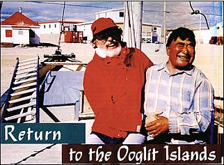
Igloolik-A grand re-union with some old hunting pals. Here Enuki Kunnuk and I share a laugh about who was better fed over the years and who got older looking…In the background is the town of Igloolik. The small white building with the red roof is one of the last of the former Hudson’s Bay Company buildings remaining from the old days of the north.

Ooglit-the place where the walrus haul out to sun themselves. An Inuit word for an ancient place. A mysterious place of tent rings, houses and circles made of giant stones, fashioned by a people long gone. A place changed by people, climate, sea creatures and time itself. A place to visit, especially as the old ones must have: by paddling an umiak or a kayak.

In the last week of July, I stood a dozen feet or so above a glassy sea in 18°C weather, on the top of several terraced beaches. Looking north, just barely visible from this slight rise above the water, the Ooglit Islands appeared to come and go, a mirage hanging above the sea. My kayak lay at the water’s edge, my lunch camp ready to be packed away. I hesitated. I knew that the arctic weather could change from placid to furious in an instant. I would definitely be taking a risk going so far offshore. I took a compass bearing. The 60°N bearing from the point here at Nugsanarsuk, out to the islands was a bearing that only a fool would trust. This close to the magnetic pole, a bearing was more changeable than the weather. It was three in the afternoon on a day when the sun wouldn’t set for another few weeks. I launched the kayak and slipped into the cockpit, tightened the spray skirt and dipped the paddle into the mirrored surface.

From the water, I couldn’t see the islands at all. Still, the Ooglit Islands drew me like a bevy of sirens, tempting me. I had visited these islands almost 30 years ago while hunting with several Inuit. We had harvested several walrus among the ice floes farther offshore and had cached the meat on the island. 
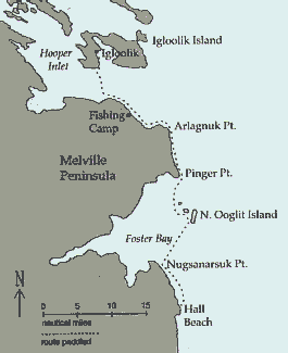
It had been a brief visit, but it was vividly etched in my memory. This was finally my chance to return. I would paddle from Hall Beach to Igloolik and, along the way, stop at the Ooglit Islands.

My kayak was flown from Montreal to Iqaluit on Baffin Island and then to Hall Beach on the Melville Peninsula. I followed it a few days later. I got a ride into town from a lanky, friendly guy in a pickup truck and asked him to take me to the village “campground.” We laughed. There was no campground, of course. I could have camped anywhere. He took me to a beach made of small, flat, grey stones, many bearing fossil impressions, at the north end of the village. Nearby were the tents of several Inuit elders who had abandoned their wooden houses for the summer months. Early the next morning I loaded the kayak. After several false starts, I managed to fit everything in except my sleeping bag, which I stowed in a dry bag on the deck behind the cockpit. I had brought along two closed-cell-foam pool-noodles to use as beach rollers. They worked perfectly, allowing me to ease the laden kayak down the sloping, pebbly beach. The water was dead calm, reflecting the partly cloudy sky like a mirror. I began following the barren shoreline northward.

Terraced beaches rose, one above the other, relics left over from the last ice age as the land, relieved of its icy burden, rebounded out of the sea. Fifty feet above the water, the rows of gravel level off and stretch inland in an almost unending series of tundra ponds, sedge meadows and low ridges without a bush or tree in sight.

I paddled a half mile off the beach, where the water was free of ice and rock hazards. The bottom was clearly visible and rocky, with a sparse covering of kelp streaming in the tidal current. Paddling for miles along such a monotonous and low-lying shore, I was never precisely certain where I was. After three hours of paddling, however, when the land turned westward into a deep inlet, I knew I had arrived at Nugsanarsuk. A beacon tower allowed me to establish my position exactly. I rolled the kayak up the beach on my foam noodles and made lunch. From the top of the highest beach terrace, looking north, I could see the Ooglit Islands for the first time. Since they could not be seen from the water, the bearing back to the beacon would become my only reference point.
As I paddled out, the horizon seemed to curl up and away from the boat, as if reversing the earth’s curve. Pieces of ice scattered around seemed strangely suspended from the sky, giving the impression I was paddling inside a smooth blue sphere of water that curved seamlessly into the sky above. The light was beginning to play tricks on me, so I kept my eye on the deck compass. Sixty degrees. About an hour into the crossing, for the first time since leaving shore, I spotted the islands, but they were lifted up, as though they were merely a mirage above the sea. I could see the shadows in the rocky headlands contrasting with some patches of white ice still attached to the shore. Then the mirage dissolved and the Ooglits were gone. I had to keep reminding myself: sixty degrees. I kept turning to check Nugsanarsuk Point behind me. Was I drifting off the bearing? I didn’t want to miss the islands and paddle out to sea! Another hour of paddling and the Ooglit Islands “mirage” made a gradual transition into the real thing. Still, they played a game of disappearing, only to reemerge in a different shape. My confidence began to falter. Patches of fog rose up and drifted past the islands, hiding them once more from view and adding to my confusion. Sixty degrees. Another half hour and I knew the Ooglits were ahead of me. As I neared the shore, currents twirled chunks of ice, big as boxcars, past me. At last, I beached the kayak on a falling tide on a sandy shore between two rocky headlands of dark pink granite.
Screaming terns and Sabine’s gulls swirled overhead as I set up my tent at the top of the beach. My thirty-year absence was over. I couldn’t wait to begin exploring. I climbed one of the granite headlands to get a look at the layout of the Ooglit Islands. I was on the largest island, North Ooglit Island, the only one with any obvious signs of past human occupation. The others were just gravel strips a few feet in elevation above the sea, visited only by birds. From the headland, the half-mile-wide band of bare, treeless land stretched two miles northward. Bays and tidal inlets cut deeply into the sides of the island, some completely emptied of water at low tide, with reversing tidal streams where the seawater flowed in and out twice a day. There were more gravel beaches, sedge meadows and shallow tundra pools. Granite bedrock jutted out in clumps here and there. About halfway down the length of the island, silhouetted against the evening sky, I could see five house ruins and some other strange structures.
Supper would be late. I clambered up the coarse, sandy beach and out of the little bay, the arctic terns and Sabine’s gulls squawking again in full fury. Walking north, I skirted rocky outcrops and shallow pools of clear water, teeming with aquatic insect life. The ground was pocked with hundreds of 2-inch holes in the ground-tunnels made by lemmings leading to their burrows-and round, shallow indentations, the empty nests of summering birds. Farther along, where an inlet cut halfway into the island, I found scores of stone tent rings, placed as if waiting for their owners to reappear and set up camp. The stones were the size of five-gallon gas cans-big enough to hold up a skin tent in the strong arctic winds. Behind the dozens of tent rings rose a gravel ridge with the remains of five Thule-culture houses. Each house was built of a circle of large boulders packed with moss and turf. Inside, flat stones were used for flooring, walls and the built-up sleeping platforms opposite the entrance. More stone was used to line the underground passageway leading outside. The roof was now open to the sky, but the presence of large whale rib bones suggested that they had once been the supports for a seal- or caribou-skin roof covering.

From the house ridge, I spotted a large circle of stones on a hilltop near the eastern shore. It was 20 feet in diameter, made of giant stones piled up chest high. Three taller stones, well beyond the height of their neighbours, were precisely positioned equidistant from each other around the circumference. In the center was a block of granite about four feet high and two feet along each side, with the sides squared off and a flat top. An altar stone? The site had been built on the highest point of land, commanding a view over the Ooglit Islands, the surrounding seas and, far off to the west, the distant hazy line of the mainland. Now at midnight, the dull, reddish sun was low in the northern sky, about to momentarily touch the horizon before rising again for a new day. Deepening shadows had spread across the island and I still hadn’t had supper.
The next morning, I sensed a change in the weather. While it was still sunny with only a few clouds, a light breeze had come up from the west. I would have to leave quickly or be stranded, possibly for days. By eight o’clock I had packed the kayak and was on the water. I paddled around the western shore looking into each inlet for possible signs of walrus and checking each rocky islet for seals before I reluctantly headed northward toward Pinger Point on the mainland. I passed three of the other Ooglit Islands, barely showing above the water and covered with hundreds of sea birds. The tidal currents were stronger now, and highly variable winds were just off my port bow. I passed through a number of tidal rips and through several lines of ice pans trapped in eddies. Guillemots and arctic loons skimmed ahead of me and then circled back for a closer look.
Again the sea air played its tricks: Pinger Point loomed high and solid in front of me, only to collapse into the water, leaving no sign of itself. Tall headlands rose up to the west, yet there was no land for nearly five miles in that direction. The constantly changing view confused and baffled me. Several times I was tempted to change course for what seemed to be the closer headland, only to have it disappear. Worries began to flood my consciousness. What if I headed out into Foxe Basin where nothing blocked my passage for dozens of miles? Even the compass was no longer as steady as it had been the day before. The only choice available to me was to continue paddling, trusting the sun’s position and the wave direction, which seemed to be the only constants.
By eleven o’clock, Pinger Point finally remained fixed and solid-looking and, a half-hour later, I was paddling alongside its gravel base. Dozens of ice pans were trapped in the shallow water, forming a maze of channels through which I wound. Many of the ice floes were crazily tilted with massive overhanging sections that dripped icy water down my neck. By noon, I had made it around the point and was relieved to find myself once again in clear water and heading northward. It was time for some lunch. As I readied my meal, the winds began to rise, first to 15 mph, and then higher. I was grateful to be off the island and back on the mainland. By two o’clock, the winds died away and I launched into a choppy sea, again moving along the shore. I could see from the kelp fronds that the current was working against me. I wanted to camp that night by one of the streams marked on the chart, but I couldn’t find any of them. I finally realised that water ran in them only during the spring. I had been passing their dry beds one after the other. I turned the kayak toward the next one I saw and rolled it safely up the beach above the tide line.
Early in the morning I awoke to the roaring sound of a windstorm, with my tent roof pressing down on me. The wind was blowing so strongly the tent was nearly flattened. Outside, the sea was a boiling mess, covered with wind-driven ice pans, spindrift and whitecaps. It was not going to be a paddling day, that was certain. To keep the fly on the tent, I wrapped duct tape around the anchoring sleeves at either end of the ridge pole and tied the biggest rocks I could carry to the guy lines. Then I buried the windward edge of the tent floor in the beach gravel, in hopes it would stop the wind from lifting the tent and carrying it away. Once I was satisfied it was not going to blow away, I went for a blustery walk. I found more Thule houses strung along the shores of a large tundra pond. The yapping of a grey fox alerted me that one of the abandoned houses was inhabited. He had dug tunnels throughout the ruined structure, and the land around the house was a brilliant green, contrasting with the monochrome beige of the surrounding landscape. It was the only place for miles getting fertilised on a regular basis.

Offshore, in the dark blue sea, hundreds of ice pans rushed dramatically past and then disappeared over the horizon. Dark clouds on the northwest horizon scudded toward me, spreading their shadows across the land. With the clouds came calmer winds and my chance to paddle again. I pushed the boat into the surf at 6:30 p.m. and charged through the breaking waves. After I had paddled a mile or so, the land turned southwest, forming a large, shallow bay. Hoping the wind would remain relatively calm for a while, I spotted a grounded ice pan on the bay’s northwestern shore to use as my reference point, and started across. The wind was very unsettled, first blowing strongly and then dying entirely, but by eight o’clock I reached the shore and was heading northward toward Igloolik once again, now only a day’s easy paddle away. The wind began to blow steadily soon after I made it to the coast, so I began looking for a campsite.
There was no beach in sight, and the steep gravel banks along the shore would make landing difficult-and hauling the kayak up above the tide line seemed impossible. Several times, I stopped to check out likely sites, but having to unload the kayak just to get it up the beach wasn’t appealing. The chart suggested that the coast would begin to flatten out a few miles along, so I dug in and paddled into the waves. By eight thirty a low point lay ahead that looked promising. I was wet and tired from constantly heading against the wind with waves breaking over the bow. I would have to stop on the point, no matter what it offered for a campsite.
As I rounded it, I saw a small wooden cabin, four white tents and a group of people who had turned to watch my progress. I angled in toward shore. What luck-I had paddled into an Inuit summer fishing camp. I nudged my way in, trying to avoid the submerged rocks hidden in the waves. Two big teen-aged boys wearing hip-waders walked out and guided the boat in. As I got out, I fell down on the hard, stony beach, a victim of cramped leg muscles and wet, slippery seaweed.
A cheery-faced man of about forty sporting a Fu Manchu moustache grabbed my cold, sore hand in his very warm one and helped me up. Two families were using this fishing camp: Lucien and his teenaged son Paulo, and Maurice and his wife Annie with their four children. Within seconds, we were all in Maurice’s tent where Annie offered me biscuits, hot tea and one of their tents in which to stay the night. Their kids, ranging from 4 to 14 years old, gathered around, anxious to get a look at their surprise visitor. Both my hosts and I tried to remember if we had ever met before, but we decided they had been too young to remember my previous visit.
Moving my belongings into the tent, I immediately recognised the layout. The floor plan was identical to the ancient ruined houses on the Ooglit Islands. Caribou skins were laid out on the slightly raised sleeping platform at the rear, and fishing gear was piled on either side of the doorway.
During the night, the winds again began to increase and, once more, I woke up with the tent flapping and pushing down on my sleeping bag. Getting up, I went outside to check what was happening. I wasn’t alone! Everyone was up, pulling on the stones to which the tent ropes were attached, moving them back to where they had been. The wind had dragged mine several feet. I added several more stones on top of each anchor stone, but even this was not sufficient, as the powerful wind continued to drag the stones. Finally, I attached my ropes directly to the next tent upwind. Satisfied that I wasn’t going to blow away, I got back into my sleeping bag. Within minutes, the whole tent came down on top of me. The ropes had pulled away from the tent completely. I crawled out from under the collapsed tent and placed some of my extra rocks on the tent to prevent it from tearing or blowing away entirely. I headed for Maurice’s tent. Alex, his 14-year-old son, was up making tea. We filled our mugs and began eating bannock when, suddenly, the tent came crashing down, waking the whole family. Alex wisely extinguished the kerosene heater before it caused any trouble, and the younger kids pulled on their clothes and went running after the family’s belongings as they disappeared downwind. The two other tents were also down, leaving only the wooden cabin still standing.
While Annie and the children collected things, the men and I rushed to save their canoes before the waves pounded them to pieces on the beach. We pulled Maurice’s heavy, 24-foot freighter canoe up higher on the beach. We walked the other canoe to a small stream nearby, where we pulled it upstream out of the surf.
We all moved into the little cabin, nine of us in the ten-by-twelve-foot building. As there were no windows, Maurice rigged up a lightbulb to his portable generator and we all took turns keeping the generator filled with gas while it ran all day without stopping. By the next day, Annie had had enough of the dark cabin interior, not to mention the noise and smell of running the generator all day long. She got Maurice to install the window he had brought from the dump in Igloolik. He wanted to put it into the roof, for fear that polar bears would break it during the winter, but in the end we cut a hole in the north wall and put it there. Next, we repaired the roof with tar paper to prevent the occasional rain squalls from spilling in through the cracks between the plywood. Fortunately, the paper was very heavy, so it was possible to roll a bit out and tack it down in the wind, which was gusting to 45 miles per hour.
Several times during our repair project, when the cabin door was unlatched, the wind would catch it and fling it open wide. If you happened to be hanging onto it, you would be catapulted out to the beach. After everyone had been flung out enough times, Maurice and Lucien built a lean-to wind screen to protect the entrance from the wind.
On the second day of the wind storm, Annie kicked us all out of the cabin and spent the day over a sizzling frying pan, cooking mounds of fresh bannock. While the kids went for walks on the beach, Lucien fished for char, which he caught nonstop in his nets, and we all ate like royalty that night. Throughout the three days of the storm, we were in touch with Igloolik and other camps in the area thanks to the CB radios everyone used.
On the third day of the wind storm, in the afternoon, the weather began to show signs of a break. The wind began to die down and the whitecaps became less frequent. We decided to head into Igloolik. By nine o’clock in the evening, both canoes were loaded to the gunwales with people and supplies and, with engines roaring, they began making their way across Hooper Inlet to Igloolik, about eight miles away. I watched as they made their way across, amazed at their warm hospitality shown to me, a person they had never met before.
Rather than head straight across the inlet, I decided to follow the shoreline and cross to Igloolik Island at the narrowest point, shortening the open crossing to around seven miles. I rolled the kayak down the beach and plunged into the surf. The waves were still about two feet high and coming from several directions at once. The wind was around five to ten miles per hour. It was going to be a wet ride.
Half an hour later, I reached the narrowest section of the inlet and headed across. The waves and currents made for a very jumbled sea. I soon realised that I would have to paddle hard constantly-there would be no letup all the way across if I were to get there. I was splashed by waves as they rushed by, with the wave crests washing over my deck.
In spite of my hard paddling, the shore ahead never seemed to get any closer. After about an hour, however, I began to see people driving around on their ATVs. I adjusted my landfall slightly to enter Turton Bay, which held the town of Igloolik. The hills behind the town provided a welcome windbreak. Even so, it took another half-hour to make my way to town. The gathering darkness of midnight, deepened by thickening clouds overhead, made it difficult to see where to land. Soaked and exhausted, I finally headed toward a group of people gathered on the beach. As the bow touched the shore, I could see Leah, a friend from Igloolik I had met here thirty years before, her brother John, and her uncle Qaminaq, the man who had first taken me to the Ooglit Islands. They were all there, waiting to greet me. I got out of the kayak and, this time, managed to stay on my feet as we hugged each other, laughing and talking all at once. Maurice and Annie had called when they arrived to tell them I was on my way, and to watch out for me. Leah had been one of the people on the ATVs I had seen, watching to make sure I was all right in the rough-water crossing.
We walked up to Qaminaq’s two-story house to meet Joanna, his wife, and one of their daughters, now married with children of her own. His son, Naisana, was no longer a toddler dressed in caribou furs, but now a father of toddlers. We downed mugs of hot, sugary tea and mouthfuls of fresh bannock. We all grinned at one another, laughing, smiling and trying to talk all at once, not really knowing where to begin the conversation. Leah worked hard to translate, but the words, mingled in two languages, came in a flood. There was just so much to say after nearly thirty years of being away. It was good to be back and especially to have returned in the traditional way, in a kayak, and from the Ooglit Islands, the mysterious islands of the past.

From Estate Sale to Ebay: The wanderings of a piece of Aleut history

For those of us who routinely troll eBay for rare and elusive treasure, Sunday nights seem to be the best time for checking for new items. As a historian living in the Aleutian Islands, I’ve used eBay as a vital source for books, photos and maps. Many of the things I’ve found on eBay, I bought for a steal from some unknowing seller. Like every eBayer, I dream of finding some ultra-rare item listed by someone who has no idea of its value.
I have had some luck with some undervalued finds: a 1788 map of the North Pacific for $29, an out-of-print book translated from Russian going for $100 on booksellers’ sites bought for $9, a rare WWII book for $5 (“Dude, you’re way too excited about this book,” the seller wrote me) and my favorite, a 1780s engraving of Captain Cook in the Aleutians for $19. These retail for $300. The seller wrote me asking, “Do you know how much this is worth?” “Yes,” was my one-word reply.
After years of scanning the hundreds of Aleutian Island–related items each Sunday night, I thought I had seen it all and bought most of it. Ogarook the Aleut—got it; The Whalers of Akutan—got it (for $30—it retails for $200 plus); WWII patches—got ’em all, doubles of most; 1869 Chart of Unalaska Bay (the first by the U.S. government)—I don’t even look at it unless it’s hand colored. You get the picture. My apartment looks like a museum of Aleutian material.
Then one Sunday in December 2005, I was knocked for a loop. The item title was “Hand-carved Aleut object.” That got my attention, although such listings usually amount to low-grade stone flakes some fisherman picked up and was passing off as arrowheads. The photo was small and unclear, so I opened the file. I sucked in a quick breath and held it. If this was real, it was big. Really big.
It was clear from the description that the seller was clueless as to its importance. The starting bid of $7 proved he didn’t know what he had. “This could be part of a sled or mask,” he guessed. It was wood and finely worked, the two main pieces lashed together. The pictures had it upside down. My eBay dream had come true.

It was the bow piece from an Aleut baidarka. For kayak historians and designers, nothing is as mystical as a true Aleut iqyax, as the baidarka is called in their language. These were the boats in which Aleuts met the first Russian explorers, and from which they fought the early Russian fur traders. In these boats, Aleut men routinely made epic trips that today require huge funding and months of planning. Fleets of hundreds of baidarkas paddled along the coast of Alaska nearly exterminating the sea -otter.
I had stumbled on a piece of history. Of course, the question of validity leapt to the forefront. Three scenarios could end the excitement early: First, if the bow piece came from a burial cave, where hunters were often entombed with their boats; second, if it was a stolen artifact; or third, if it was a leftover from a recent baidarka building class so popular in the Pacific Northwest. So where did it come from?
The seller said that 20 years ago, he had arrived late at the estate sale of anthropologist Ted Banks and was only able to acquire a few books and two unidentified artifacts. He had recently decided to sell the two artifacts, the bow and a bailer for a baidarka, though he didn’t know what they were.
Ted Banks was a (in)famous anthropologist in the Indiana Jones genre. Stationed here in the Aleutians in WWII, he returned to the islands in 1948 as part of a two-man expedition to collect plants, rocks and any artifacts he could get his hands on. This began a 40-year career of less-than-scientific archaeology and exploration. One famous incident, which he writes about in one of his many books, was his discovery of a burial cave. He reached into the small opening, feeling a mummy covered in an exquisite woven grass mat (Aleuts are considered to be the best weavers in the world). He yanked on it and tore a piece off. His expeditions sometimes consisted of dropping graduate students off on remote beaches saying, “Explore” as he motored away. Most of his collections are now housed in the Museum of the Aleutians.
If Banks had grabbed this bow piece out of a burial cave, by federal law, it would have to be returned. In fact, if it had been taken from the local people by any less-than-ethical method, it should be repatriated.
I threw out a bid of $15 and began a short investigation of Bank’s history, searching for a reference to the piece. At the University of Alaska library in Anchorage, where all of Bank’s papers are stored, there was nothing about collecting a bow piece from a cave or anywhere else for that matter. Several calls and emails to archaeologists and historians turned up no mention of the object. Things were looking up. I raised my bid to $75 just to keep in the game. You can set a bid limit on eBay to automatically increase to your maximum.

There are some tricks to bidding on eBay. The first is to keep bids low until the end. You don’t want to allow someone a week to get used to a high bid—you hit hard and fast at the end, a practice called “poaching” or “sniping.” In my small hometown of Unalaska, there’s an added courtesy of not outbidding a local who has dibs on something. (I unknowingly did this once and got in a bidding battle with someone trying to give me the item as a gift.)
In the post office Monday, I was told that someone else in town really wanted the bow piece for her husband’s Christmas gift. This was a terrible blow to me as it meant two things: One, I was going to have to crush a friend of mine, because I wanted it badly and wasn’t willing to step aside; and two, the secret was out. Foolish me—I thought I was the only one who had seen it. Let the war begin, I thought.
The seller had no idea what was happening in this remote Alaskan community. He had committed one major faux pas in setting up his auction. He had started it at 9 A.M. Michigan time, which meant it would end a week later, at 5 A.M. Alaska time. He wouldn’t get top dollar because there wouldn’t be much poaching on this one. I was lucky that I was on Christmas break and would be able to sacrifice a good night’s sleep to get in on the final hours of the auction.
The bidding started out mellow, $75 to $100 in the first two days. By the end of the week, it was still lowballed at $200. Someone must have told the seller what he had because the word baidarka appeared in the item description. Fortunately, the word was misspelled, so it wouldn’t bring in whole other segments of bidders using baidarka as an eBay search word. Nice.
I stepped things up with a $400 shot to get rid of the amateurs. It was nearly immediately topped by a bidder identified as “arcticarchaeologist.” He’s a good friend, and I knew this was getting serious. I smirked when I saw his bid trumped by “bitsofak.” Arcticarchaeologist came back raising the ante by another $250. I could hear the seller gurgling with joy. With one day left, the bids slowed. I was waiting to snipe the archaeologist in the end, but then a new player entered a yet higher bid. He even upped his own bid by $100 to $700 after he placed it. Perhaps right before his bedtime.
Down to the Wire
I came home from a Christmas party at midnight. Time to play hardball, I bid $1,002—another eBay trick, adding a few dollars to a round number—and hit the sack. When the alarm rang at 4:45 A.M. a heavy snow was falling. This meant my satellite dish would be full of snow and the Internet link it provided would not be working. Another option was my cable modem, but when I logged in, my access was denied—there was snow in the cable company’s dish as well. I called a friend who was monitoring the action on a landline link. “Dude, you’re on top with 43 seconds to go!” Seems my rivals slumbered too late. Forty-three seconds later, I was the proud owner of a genuine late 1800s Aleutian baidarka bow piece.
When the piece arrived, I was surprised at how small it was. The second thing that struck me was the presence of nails and a large brass screw, neither of which were traditionally used in kayak construction. But all that paled when taking in its delicate beauty and fine craftsmanship.
The piece is a textbook example of an Aleut bow shape. It is known as a bifid bow because of the open slot, which allowed the skin covering to take a more seaworthy shape. Bows from the Aleutians differed from their neighbors to the east, the Pacific Eskimos, in that the bow was made in two pieces and lashed together—in this case, with split spruce root.
The most unusual characteristic of this specimen is that the lower piece was lashed to the keelson. In most recorded examples of Aleut kayak bows, the lower piece is carved to include the forward segment of the keelson. In this one, it attaches with a hooked scarf joint, a characteristic of all Pacific Eskimo boats but incorporated only late in the 1800s in Aleut uluxtux, or double-cockpit kayaks. These two-man kayaks were made by the Alaska Commercial Company and sold to the hunters. (A full frame with an identical bow piece is in the Burke Museum in Seattle.)
Another unusual feature is the upper piece. The upper part of the Aleut bow flares to add buoyancy and is traditionally all one piece. On this Banks-collected piece, however, the top plate is nailed on to the flared piece. Metal fasteners are rare in Aleut boats. The upper bow piece is the most difficult to shape, and this variation seems to be an unusual but effective solution to its construction.
The commonly recognized upturned curve of the lower bow piece is just one variant of Aleut boats and the most frequently used by those re-creating the baidarkas. The earliest recorded Aleut kayaks had straight horizontal and parallel bows. This required lashing a stick across the opening to prevent seaweed and other debris from getting caught in it. In later designs, the upturned lower bow piece performed in the same capacity as the stick.
On two- and three-hole boats, the top plate also had an upward-turned projection. Its function is unknown but may have allowed a gun or spear case to be tied off to it. The piece I’d purchased is missing that horn, and the brass screw is in the place where it would have been attached.
Traditionally, Aleut kayak frames were painted with red ochre to preserve the wood and to symbolize the blood of the “living” boat. The Banks bow has some traces of red on it but most seems to have faded into a dark patina. The curved part apparently had been worked on, as the wood is free from any coloration.
The design, crafting and assembly of the bow piece connects us with the greatest kayakers in the world—the Aleuts of the past. I often sit and stare at the piece, noticing new subtleties in color, nuances of shape and tool marks showing techniques, and daydream, especially during the cold of winter, of digging out my pale plastic descendant of this amazing craft and paddling the same waters as the original owner of this piece.

Trouble at the Tombolo

Steve turned on his VHF radio at the La Push Marina parking lot. It was well before 9 A.M., the scheduled meeting time. Five other kayakers on a kayak club outing would soon join him that August morning for a three-day, nine-mile trip south along the Washington coast to Toleak Point. He listened to the weather report: five-foot northwest swell, light winds. A threat of coastal fog was a concern, but he could see that conditions were good.
Steve stepped out of his vehicle, lifted his kayak off the roof rack and readied his gear for the launch. An expert sea kayaker, over the past 15-plus years he has led many club trips and clinics on the outer coast. He rated the trip a Class IV to V, on a scale of I to VI, because of the variable conditions, open-coast exposure and possible surf landings. With the favorable weather report, Steve looked forward to having an enjoyable summer adventure.
Judy arrived next. She was a seasoned paddler, but she had told Steve before the trip that she had only limited experience with surf launching and landing. Steve knew that there were many protected beaches on this stretch of coast, and given the strength of the rest of the group, he didn’t think Judy’s level of skill would be a problem. I was next to arrive, followed by Beth and Rob, then Scott. Beth and Rob had some ocean paddling experience and had worked aggressively on their skills, including rolling and assisted rescues. They were looking forward to this trip as a test of their skills. Scott was an expert paddler and in great shape. (He would later win the sea-kayak division of the 2005 San Juan Challenge.)
Introductions weren’t needed—we had all paddled with each other before. As we were packing, Steve did a gear check and reviewed the trip plan. He asked who had spare paddles, VHF radios or towlines and if anyone had any special needs. He instructed us to set our radios to 69, the channel we’d use to communicate with each other.
I told Steve I didn’t want to be involved in any rescues—should they come up—because I’d injured my shoulder. I’d even left my towline at home, because I didn’t want to make myself available for towing. Steve carried two towlines on his person: a 50-footer on a belt and an adjustable-length line, set at a short length, in a PFD pocket. He tucked a third, short line under the bungee on his front deck. He had an additional belt-towing system, which he handed to Rob. Scott and Judy had towlines as well. Judy stowed hers in her day hatch. All of us had PFDs, helmets and flares. Steve and Rob each had a GPS. Steve said he wanted to stop at James Island at the mouth of the Quillayute River to be sure he got a waypoint. If we returned in fog, he said, it would be crucial to be able to make our way to the narrow river entrance between James Island and the jetty that protects the waterway.
Although it was the height of summer, the cold water of the Pacific required that we wear thermal protection. Rob wore a wetsuit, as he prefers its reliability when paddling around rocks—a cut or tear won’t compromise a wetsuit as it would a dry suit. I prefer a dry suit because it keeps me warm at campsites and on breaks. It can be overly warm for summer paddles but is still my choice for cold-water immersion. Judy and Beth were also in dry suits. Rob put on his Farmer John wetsuit, with a thin, long-sleeve neoprene top. Steve wore a wetsuit and paddling jacket. Scott chose to wear a shorty wetsuit, his choice for mild conditions.

Tactics for Turning

In calm conditions, a sweep stroke is usually sufficient to turn a kayak, but when the wind blows, turning a kayak may require something more. Depending on the relative direction of the wind and the direction you want to turn, some strokes will work more effectively than others. In choosing which strokes to use, it’s helpful to understand how the forces imparted by the wind and the water affect the directional control of a kayak. You don’t have to struggle in the wind if you use strokes that let the wind do some of the work for you.


Weathercocking
As the kayak moves forward through the water, the bow and stern encounter different forces. The bow moves forward into undisturbed water and pushes it aside. At the stern, the water moves back in to fill the void created by the passage of the middle of the kayak, leaving turbulent water in the kayak’s path. In calm air, these forces are balanced on both sides of the kayak. But if the wind is blowing against the side of the kayak and pushing it sideways (and here we’ll be considering the behavior of kayaks without rudders or skegs or with those devices retracted), the bow meets more resistance in the undisturbed water than the stern meets in the turbulent water.

Because the stern of a forward-moving kayak has lower lateral resistance than the bow, it is more readily pushed downwind. The net result is that the kayak changes its heading, a phenomenon referred to as weathercocking. From the paddler’s perspective, the bow seems to be pulled up into the wind. As the paddling speed increases, difference in lateral resistance between bow and stern grows and the kayak veers more forcefully upwind.

Choosing your strokes to work in concert with the forces imparted by the wind on the kayak will improve your performance and reduce the effort required to manage your kayak. Turning the kayak in the wind begins with good forward speed and by using the paddle effectively on both sides of the boat. For turning in wind, you’ll need good basic skills with the sweep stroke and bow and stern rudders.

The Forward Sweep Stroke
The forward sweep stroke is the fundamental stroke for turning a sea kayak. The sweep is a modified forward stroke that adds to forward momentum and causes the kayak to turn. Consider a turn to the right—the stroke is preceded by an initial upper torso twist clockwise and then the left paddle blade is planted well forward on the left side of the kayak. During the stroke, you unwind the lower torso to turn the kayak against the resistance of the paddle. At the end of the sweep, you’ll have to withdraw the paddle blade from the water quickly or it will reduce the momentum of your turn.

The sweep stroke uses only one paddle blade, but you can use both blades to turn. For more turning power, combine two strokes into a smooth sequence, and follow the sweep stroke on one side with a bow rudder or a stern rudder on the opposite side.

The Bow and Stern Rudders
Rudder strokes are performed by placing the blade either forward or aft of your hips and holding it in a static position. The power face of the paddle is the side normally facing you (usually the concave face bearing the manufacturer’s label) and the back face is the side normally facing away from you. For a bow rudder in the wind, the paddle shaft is held in a nearly vertical orientation, and the blade is placed in the water at a forward position near or beyond your knees. The power face of the blade is toward the kayak, with the leading edge of the blade rotated slightly outward, creating an angle of attack that pulls the bow into the turn.

A stern rudder works in a very similar way but has the paddle shaft in a more horizontal orientation, with the blade placed well aft of your hip. The blade is in a nearly vertical plane and the power face is toward the kayak. The paddle shaft is positioned to create an angle of attack so that the water pushes against the back side of the blade, which then pushes the stern to the outside of the turn. Effective bow and stern rudder strokes require subtle adjustments of blade position and angle of attack.