
Our kayaks were lined up like driftwood along the sand and stone beach when we heard the long, sharp Miller Ferry whistle in the distance. The sound welcomed the beginning of another trip to the Erie Islands and our launch from the Ohio mainland for a three-day weekend of paddling among the largest collection of islands on Lake Erie.
Located in the western basin of Lake Erie, the Bass Islands and their surrounding sister islands are part of a 21-island archipelago located in some of the richest walleye fisheries in the world.
While well known as a sport -fishing destination, the islands also offer some of the best paddling opportunities on Lake Erie. The island chain, separated midway by the international border with Canada, is steeped in history from its roots as a Native American fishing grounds to its grape -growing heritage and its pivotal naval battles during the war of 1812.
You can make the easy crossing from Catawba Island to the campground at South Bass Island State Park from several mainland locations. There is a public beach launch location just east of the Miller Ferry dock and another at Catawba Island State Park.
To add a few more shoreline miles, you can put in further southeast at the Mazurik public boat launch near Marblehead, Ohio. The three-mile crossing to South Bass Island takes kayakers across a busy boat and ferry channel, but be attentive and respectful and you should have no problem negotiating vessel traffic. Give a wide berth to the active ferries serving the island.
We edged our boats into the water from the little beach east of the Miller Ferry and paddled past Mouse Island toward the southern tip of South Bass Island, where its lighthouse greets boaters coming from the mainland. For the many day-trip opportunities in the Bass Islands, paddlers usually split off before the light and head east or west toward their selected adventures.
I prefer to paddle west around the rocky coast to South Bass Island State Park and set a base camp, then day-paddle throughout the islands for a nice, long paddle weekend. When you visit the islands for the first time, it’s easy to spend four or five days linking multiple island crossings and shoreline for more than 40 miles of water. Paddlers looking for a three-day weekend getaway or more can find many interesting shore and historical sights among the islands.
South Bass Island State Park offers cliff-side campsites reserved for tent campers, and the vistas overlooking the lake are a perfect post-paddle reward. These sites sit more than 100 feet above the water and you can set your tent as close to the lip as you dare for maximum viewing pleasure.
It’s only a short carry from the beach to the closest sites but we typically leave our boats lined up on the grass above the rocky beach and lug the gear up the slope to camp. The small harbor and breakwall off the beach provides a great location to practice rolls and rescues when the wind cooperates.
On previous trips, we always seemed to draw a small crowd of spectators who enjoyed watching us turn upside down and sideways during practice. On this trip we planned to put some miles behind us, so we launched our boats over the cobblestone beach for the afternoon paddle into the island’s main harbor.
All of the islands in the chain are limestone bedrock and paddlers usually follow the steep cliffs from camp four miles around the northwest shore to the harbor village of Put-in-Bay.
Cottages dot the cliffs above the water along this section. From a kayak you get a unique perspective of Benson Ford’s Shiphouse, a freighter which was removed and craned to the cliffs as a summer home in 1986.
At water level, the broken shoreline leads paddlers through a playground of rock gardens that dot the base of the cliffs. Depending on lake levels and wave action, there are several carved out caves where you can poke your kayak and many dynamic rocky play areas.
Paddling into Put-in-Bay Harbour, you’ll wind through sailboats bobbing at mooring balls and water shuttles bringing boaters into the busy maritime village. The little rocky beach at the edge of DeRivera Park, next to the Boardwalk restaurant, makes a convenient rest stop.
Stretching your legs, you’ll peer over the breakwall and back into time at the village’s nautical-themed, gingerbread framed shops that face the waterfront and park. This destination offers a convenient option for paddlers; they can rough it at the state park camp or wander into town for a beverage, perch dinner and nightlife.
Gibraltar Island and its steep, rocky shoreline is a paddling gem that guards the harbor entrance.
It’s home to college research laboratories instrumental in tracking lake biology and preserving the rare and threatened Lake Erie water snake. From time to time Stone Laboratory, the oldest freshwater biological field station in the United States, hosts open houses for visitors interested in learning about the ecology and biology of the lake.
The Stone Laboratory anchors one end of the island and Cook Castle sits high on the cliffs at the other end. Paddlers can also stop at the joint Ohio State University and Ohio Department of Natural Resources (ODNR) outreach facility across the harbor at Peach Orchard Point. Exploring the waters around Gibraltar Island, you’ll wind your way around car-sized boulders and under rocky overhangs that block out the surrounding boat traffic.
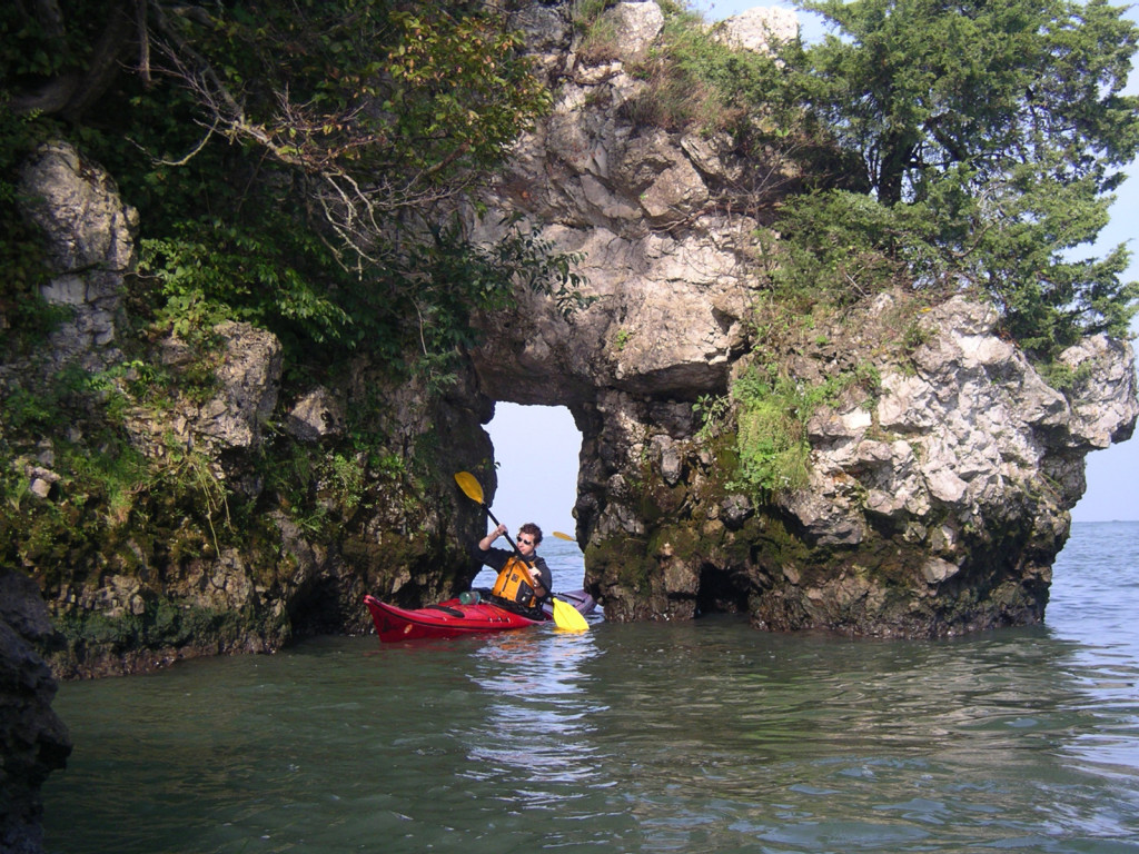
The highlight of your Gibralter circumnavigation will be finding Lake Erie’s only natural sea arch, the Needles Eye. Threading the needle is a paddler’s tradition.
As you head east out of the harbor from Gibraltar Island you’ll also be in the shadow of one of the most impressive sights on Lake Erie: Perry’s Victory and International Peace Memorial.
This fluted, granite Doric column, topped with an observation deck, stands 352 feet (47 feet taller than the Statue of Liberty) above the island and symbolizes the long-lasting peace between Britain, Canada and the United States. On a clear day the observation deck provides views of the entire western basin, islands and Canada. During the summer of 1813, Commodore Oliver Hazard Perry sailed from Put-in-Bay Harbour to fight the British in a battle that would help close out the War of 1812. Perry commandeered the Brig Niagara after his original boat, the Lawrence, was disabled.
With the Brig Niagara, Perry proceeded to outflank the British on his way to U.S. Naval victory. Vessels around the islands still fly versions of his famous blue banner that read, “Don’t Give up the Ship.” A kayak trip through these islands follows in the footsteps of this famous battle.
For a day-paddle destination, there is a small beach on the southern side of the island, near the visitor’s center. Kayakers can land and take a short walk to the tower and visitor center. If you listen closely and squint your eyes from the lookout deck, you can almost hear the ring of cannon fire and see naval vessels sailing at a distance through the milky haze.
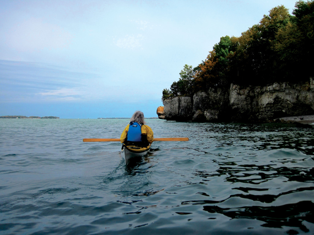
Continuing your circumnavigation of South Bass Island, you’ll find 12 miles of rocky shore, well-kept summer homes and the Scheef East Point Nature Preserve. Activists and the state helped save this point of land from development and created a nine-acre preserve vital for the migrating birds and the preservation of the very rare Lake Erie water snake.
Just recently removed from the federal endangered list, this reptile was at the brink of extinction until efforts were made to save, track and restore its habitat. A day paddling the islands becomes complete when you see one of these mild-mannered gray heads poking out of the water along the shoreline. As you round the southern lighthouse point and head back to the State Park, give the Miller Ferry Line a wide berth as you’ll need to pass in front of its landing at the Lime Kiln Dock to make the turn back to camp.
The steep cliffs and strong current in this section also make for choppy waters, so be on your game when paddling near shore.
You will find a full day of paddling if you stick to the host island, or you can use South Bass Island as your jumping-off spot to a number of crossings and longer day-paddles. For our favorite full-day, 20-mile paddle, we leave Put-in-Bay Harbour and cross over to Middle Bass Island.
We then head north past Sugar Island, around the eastern shore of North Bass Island and then cover two, five-mile crossings to Rattlesnake Island and Green Island before landing back at the state park on South Bass Island.
As another option, you can also circle Middle Bass Island, paddle around Ballast Island and complete a circumnavigation of South Bass Island. With charts and your imagination, you can create any number of day trips of varying lengths among the islands.
If you cross from Put-in-Bay Harbour to Middle Bass Island, you’ll see a gothic castle that was once the main building for the former Lonz Winery. Now owned by the State of Ohio, there is a marina and a half dozen rustic campsites with beach access that paddlers can reserve through the ODNR.
Started during the Civil War, the former Golden Eagle Winery was the largest wine producer in the United States in 1875. Several of the islands have a rich history in wine production, as the climate and soil are known to support rich harvests. Grapes are still grown on several of the islands and sent to the mainland for processing.
Heading north, you can follow the Middle Bass shore past Sugar Island and out to North Bass Island. Members of the Native American Ottawa tribe once used the island as a fishing, hunting and trade outpost, and up until 1822, the border with Canada ran through the island before it was moved farther north.
North Bass Island doesn’t offer the same steep, rocky shore as some of the other islands, and Manila Bay on the northwest corner of the island is a good lunch stop.
Here, the clear water skirts what appears to be a white sand beach, but upon parking your kayak you’ll find it’s really a vast accumulation of broken zebra-mussel shells. Still considered an invasive species, the zebra mussel shells have actually helped filter water in Lake Erie, effectively improving water clarity from inches to feet.
The improved clarity allows sunlight to penetrate deeper into the lake, causing various plant and bacteria organisms to grow, decay, then pop back up as algae, a growing concern for Lake Erie biologists. If you want to bushwhack, there’s also a shallow grass and tree lined inlet to a small three-acre inland lake towards the northeast corner of the beach.
North Bass Island is currently uninhabited and was purchased in 2004 by the State of Ohio with the intention of preserving and letting nature retake the island. The state operates the island as North Bass Island State Park, where primitive camping and low impact activities are allowed with a permit.
To preserve the history of wine production, the state leases 38 acres to the Firelands winery and future plans include trails and access to the chapel, school, cemetery and several historic homes that still occupy the island. Only a mile from the Canadian border, this remote island allows for excellent secluded camping and exploring.
Experienced paddlers can link several long crossings together to make a full-day of paddling by leaving North Bass Island and heading southwest to Rattlesnake Island.
This island is privately owned, but houses a club and a three-hole golf course that doubles as a landing strip. Legend holds, the island has a long history with private ownership, organized crime and prohibition bootlegging.
The current owner/membership list is extremely private and the land is off limits. While the island is very private and doesn’t allow boat landing, the high cliffs, carved out limestone water-level caves and surrounding rock outcroppings that form the island’s “rattles” are fun to explore.
There is a small metal lighthouse protecting the entrance to a tight marina, and while powerboats are dissuaded from seeking refuge, a paddler should have no issues landing in an emergency.
Turning southwest from Rattlesnake you’ll see Green Island in the distance. Now an ODNR wildlife refuge, this island is uninhabited and displays rugged shoreline like many of the other Bass Islands. Several lighthouses once stood watch from this island and now an automatic light guides vessels through the south passage around the Erie Islands.
Weather and waves have calved off large chunks of the island, inviting a fun rock-play experience. Rebounding waves may keep less experienced paddlers away from shore, but experienced paddlers can venture closer and run through some of the technical slots in the rock.
Landing is difficult on this island, but there is a low depression in the far western side of the island where you can land if necessary. After balancing your boat on the rocks, careful and adventurous paddlers can climb through the vegetation to see the remains of the limestone lighthouse and keepers quarters.
The roof and internal structure were lost to fire and the elements long ago, but the large, carved “1864” above the doorway still stands watch over the island and the birds that now call it home. Only two miles from the state park and camp, paddlers can zip back to South Bass Island and home after a long day of crossings and open water paddling.
Many paddlers are introduced to the islands via the South Bass Island Kayak Rendezvous, held each June at South Bass Island State Park.
Each year more than 100 kayakers gather and paddle the islands during what park officials call “Kayaker Weekend.”
Kelleys Island
Kelleys Island should be included in your list of Lake Erie paddling adventures. Slightly outside of the scope of the Bass Islands, and seven miles away through open water, Kelleys is the second largest Lake Erie island and home to a year-round population of 360 people.
Kelleys shares a similar Native-American and maritime history with the Bass Islands in addition to serving as a large quarry through the 1940s and an active commercial fishery into the 1950s. The island is home to loyal village residents, a lush state park and a commitment to keeping a lot of the island reserved in its wild state.
You can paddle its shores after making the five-mile mainland crossing from the Mazurik State Boat Launch or from Catawba Island. Access from the Mazurik Launch places you closer to your vehicle if you have to leave the island by ferry. The rocky shore does not include steep cliffs, but paddling along the North Shore Alvar offers several miles of opportunity for rock exploration and seclusion since cottage development is not allowed in the area.
You can also hike this shoreline from the 677-acre state park on Kelleys Island. The park offers a wide and well-kept sand beach and many lakeside campsites. Each September the Island Audubon Club and State Park host the Kelleys Island Poker Paddle and more than a hundred paddlers descend upon the island for a weekend of socializing and paddling.
With a strong northeastern wind, the eastern and southeastern shore can be a fun surf run, and there are at least 15 miles of shoreline to paddle if you circumnavigate the entire island.
Pelee Island
If you’re an experienced paddler, wait for a good weather window to paddle nearly 20 miles through the Erie Islands to Pelee Island on the Canadian side of the border. Crossing the international border in the middle of Lake Erie is a neat life-list check-off.
More than once I’ve been greeted with confused, “You came by arm?” responses from the French Canadian customs agents on the other end of the phone when I called with my passport. Even the phone location is interesting, as you direct dial from a 1970s-era phone booth sitting outside the historical museum at west dock.
Pelee Island is the largest Erie Island and is nearly nine miles long from tip to tip. Camping is at the Anchor and Wheel Inn and at the municipal campground on the east side of the island. The shoreline is mostly beach and breakwall, but the island community, its natural areas and winery are worthy reasons to visit, and it’s a bonus if you can get there via kayak.
The two most distinct features accessed by land and water are located at the extreme tips of the island. To the south, the Fish Point Provincial Nature Preserve and its long sandy beach offers many opportunities for hiking, bird-watching and exploring the natural habitat.
To the north, Lighthouse Point Provincial Nature Reserve includes trails and the restored Pelee Island Lighthouse. On land, the island is too large to navigate without using a taxi or renting a bicycle, but there are many day adventures to tap into with some advance research.
In accordance with the wine-making history of the islands, Pelee Island Winery offers tours and tastings. If you don’t arrive “by arm,” you can bring your kayak to the the island by ferry from Sandusky, Ohio or Leamington and Kingsville, Ontario.
The Erie Islands have long been a boater and fisherman’s haven, and now the islands have a growing reputation as an eco-friendly destination for kayakers. From day-paddling expeditions to week long adventures, the Erie Islands offer a multitude of sights and distances for kayakers of all levels.
A tour through the islands will carry you over waters that are rich with history, island life and natural preservation.
Eric Slough is a kayaker based in Toledo, Ohio and loves paddling throughout the Great Lakes. He is the co-coordinator of the South Bass Island Kayak Rendezvous held each June at South Bass Island.