 |
|---|
|
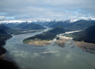
The proposed road route would cleave the
fragile delta at the head of the bay. |
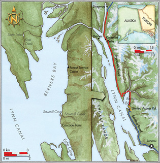
Berners Bay, a bit of Eden in Southeast Alaska, has long been cherished by kayakers and other outdoors enthusiasts. It lies on the west side of Lynn Canal, 35 sea miles north of Juneau, and is accessible only by boat or seaplane. Its biological richness and unmarred coastline offer unsurpassed opportunities for a true wilderness experience; however, a contentious plan to rim the bay with a major highway development could spell big changes for both the place and the people who love it.
Garbage and Gold
My partner, Rosemary, and I shoved off into an ebbing tide at Echo Cove, at the south margin of Berners Bay. Our fully laden kayaks were sluggish until we settled into our paddling. Dozens of salmon leapt all around us as we made our way toward more open water.
As we moved out of the cove, we could see the six-mile-wide expanse of Lynn Canal, North America’s deepest fjord. To the west across the canal was the jagged spine of the Chilkat Mountains. A cliff to the east buckled the waves into a cold chop. Harbor seals broke the surface into the clouds’ woolen light to stare at us.
At Cascade Point, a fresh three-mile-long road swath cut through the forest, linking Cascade Point to the highway at Echo Cove. Spent rifle cartridges, empty beer cans and spoiled toilet paper littered the woods along the roadside. A trail of orange survey flags marking the proposed continuation of the road led deeper into untouched stands of hemlock and spruce, opening the forest to the prospect of more of the same abuse.
The politics of the proposed pavement are murky. Former Alaska governor, Republican Frank Murkowski, through his “Roads to Resources” initiative, sought to connect Alaska’s capital, Juneau, to the continental road system in Skagway. Murkowski’s “Juneau Access Road” would pave 65 miles of wilderness coastline in the upper Inside Passage at a cost of $300 million. He claimed the road would meet demands for improved access to the state capital from nearby communities Haines and Skagway, both of which relied on state-subsidized ferry service.
But Murkowski’s proposal raised the ire of the residents of Juneau, Haines and Skagway. In nonbinding referendums, voters opted to improve existing ferry service instead of developing the road. They believed the ferry was more cost effective, reliable and safe and feared that hazardous winter road conditions—the proposed road would traverse 61 avalanche areas—would frequently make the road impassable and pose considerable risks to human safety.
 |
|---|
|
Map by Christopher Hoyt
|
Murkowski then defied common sense by proposing to discontinue the existing mainline ferry service connecting northern Southeast communities and dead-ending the proposed road 18 miles short of Skagway, making it a gargantuan road to nowhere that would require new shuttle ferries to link it to Haines, some three miles across the waters of Lynn Canal from the road’s end.
Letters of opposition poured into area newspapers. Wildlife managers chimed in with concerns over the road’s impact to critical habitat for Stellar sea lions (listed as threatened under the Endangered Species Act), brown bears, bald eagles and salmon. Still, the Murkowski administration remained cemented. “We need people who don’t understand to get out of the way so we can move forward,” said Department of Transportation Regional Director, Gary Paxton (Juneau Empire, Sept. 17, 2003).
Locals wondered if the “we” Paxton was referring to included mining company Coeur Alaska. This subsidiary of Idaho-based precious-metals giant, Coeur d’Alene Mines Corporation, was planning to reactivate Kensington Gold Mine above Berners Bay. Since taxpayers would pick up the road’s multimillion-dollar construction bill, the proposed road would be a burden to the citizens of the state and a boon to Coeur Alaska; a state-subsidized means of transporting workers, ore and equipment to and from the mine site.
 |
|---|
|
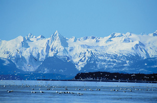
Gulls feeding on eulachon with the Chilkat
Range beyond. Photo by Ronald L. Dunlap |
Conservation groups including Southeast Alaska Conservation Council (SEACC), Sierra Club and the Natural Resources Defense Council (NRDC) filed lawsuits against the mine and the road project. One suit contends that Coeur Alaska will violate the Clean Water Act if allowed to dump 4.5 million tons of waste into as yet untarnished Slate Lake, which drains into Berners Bay. The other suit asserts that the Federal Highway Administration failed to thoroughly consider ferry alternatives for Juneau access. It also claims the Forest Service inadequately assessed the road’s impact to wildlife in Berners Bay and Lynn Canal. Both suits are awaiting court hearings.
In the interim, some local residents took more direct action. Haines High School swim coach, Steve Vick, swam 92 miles along Lynn Canal, paralleling the road’s route to raise awareness; a protest camp sprang up at the road’s proposed terminus on the unmarred Katzehin Delta.
Alaskans deplumed governor Mur-kowski in the 2006 primary election, voting for Republican Sarah Palin by a 32 percent margin. But before leaving office, the lame-duck governor tried to commit the new administration to building the road by pledging $30 million in state funds to blaze a one-lane “pioneer road” to Slate Creek beneath Kensington Mine. Murkowski also tried to sidestep the permit process by taking bids for the road’s construction before the Army Corps of Engineers had issued the necessary permits. However, Governor Palin axed the pioneer road until the new administration has fully reviewed the project. Palin supports increased Juneau access, but whether she believes that should be accomplished through a road or better ferry service remains to be seen.
The Natural State
 |
|---|
|
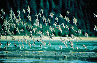
The delta is an important stopover for
thousands of migrating shorebirds each spring. Photo by Ronald L. Dunlap |
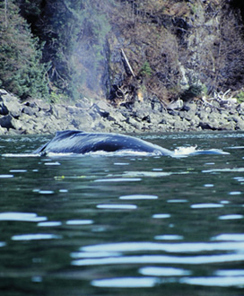
The Coast Range rises to the east high above the barnacled tidelands of Berners Bay. Four major rivers flow through dank rainforest valleys before spilling into the bay. In spring, when the tiny smelt-like eulachon and herring arrive, the bay and the massive delta on its north end become a central feeding point for thousands of shorebirds, some 900 Stellar sea lions and dozens of humpback whales.
Though the eulachon had already come and gone by the time we arrived, the salmon were there in full force. We entered Sawmill Cove where thousands of pink salmon stacked up before making their final push to their ancestral spawning grounds. The sky whirled with eagles, ravens and gulls, while on the water marbled murrelets, sea otters, porpoises and seals churned as they gorged on fish flesh.
I raised my binoculars toward Sawmill Creek. Along its western bank, coastal grizzlies had worn deep troughs leading from their resting places in the old growth to their preferred fishing spots along the creek. I knew that behind the cove, the orange survey flags hung from tree branches, signaling the changes that might come. I wondered how the architects of the road felt as they walked the survey line. Sheltered by the coniferous green of the Tongass, with all of Berners Bay sloshing at their feet, did they ever feel hushed by this landscape and consider keeping it intact?
During our seven-day trip, it didn’t surprise us, given the bay’s close proximity to Juneau, to see other kayakers, fisher folk and a guided group of paddlers. But the places visitors go ashore are free of the usual dross of civilization that you might find alongshore near a major population center. The surprising absence of trash in spite of the area’s many visitors gives the distinct impression that the people who go to Berners Bay care deeply for it. Small primitive sites are established at different haul-out points along the coast. At one beach, a half dozen tent spaces are nestled inconspicuously beneath the cover of giant trees with but one central fire ring shared by all. Even the creek running through the site seemed so pure that I risked sipping from it unfiltered and never had to regret doing so.
On a Road to Ruin
 |
|---|
|
Humpback whales are frequent visitors.
Photo by Ronald L. Dunlap |
Farther down the south side of Berners Bay, a Forest Service cabin sits open for public use. It’s cheery inside with an oil-burning stove, several bunks and cupboards stocked with food donated by campers. A logbook rests on the kitchen table. In it, words of adoration for the bay fill the pages.
What makes Berners Bay an anomaly is simple: It doesn’t have a road. By and large, the people who go there know the risks of traveling by boat in an area where conditions on the water can become downright dangerous. The same respect they have for the water applies to the places they come ashore. Neither campground hosts nor citation-issuing rangers have been necessary to maintain the primitive sites. The campers who use them attend to them out of a sense of personal responsibility. Their understanding of the wilderness sets them far apart from those of the car-borne crowd who can’t differentiate one party spot from the next.
Proponents of the road would be happy seeing that changed. They say the road will be a conduit for recreational opportunities sought by RVers, ATVers and snowmobilers. In their vision of Berners Bay, gas stations, resorts and drive-up campgrounds would occupy beaches where now bears are the only regular traffic. But greater access will only grind Berners Bay down from a cornerstone of Southeast Alaska’s biological diversity, where the human and nonhuman worlds interface in a rare delicate balance, to a place overpowered by the roar of motors.
 |
|---|
|
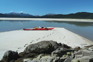
A quiet beach at the head of Berners Bay.
Photo by Rosemary Jackson |
On the last night of our trip, we stayed out late, paddling silently in the midnight sun’s dimming light. Far from the clamor of years of public outcry, far from the courts where attorneys will argue the fate of Berners Bay, we heard only the sound of the tide lapping a barnacled shore.
